You are here: Home > Network List > GS - US Geological Survey Networks Stations List
> Station OK029 Liberty Lake, Oklahoma, USA > Earthquake Result Viewer
OK029 Liberty Lake, Oklahoma, USA - Earthquake Result Viewer
| Earthquake location: |
Near Coast Of Ecuador |
| Earthquake latitude/longitude: |
-0.3/-80.5 |
| Earthquake time(UTC): |
2017/06/30 (181) 22:29:44 GMT |
| Earthquake Depth: |
7.4 km |
| Earthquake Magnitude: |
6.0 Mww |
| Earthquake Catalog/Contributor: |
NEIC PDE/us |
|
| Network: |
GS US Geological Survey Networks |
| Station: |
OK029 Liberty Lake, Oklahoma, USA |
| Lat/Lon: |
35.80 N/97.45 W |
| Elevation: |
333 m |
|
| Distance: |
39.3 deg |
| Az: |
338.008 deg |
| Baz: |
152.573 deg |
| Ray Param: |
0.07509328 |
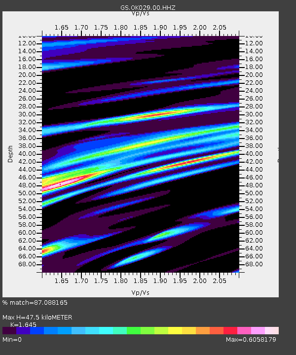
| Estimated Moho Depth: |
47.5 km |
| Estimated Crust Vp/Vs: |
1.64 |
| Assumed Crust Vp: |
6.426 km/s |
| Estimated Crust Vs: |
3.906 km/s |
| Estimated Crust Poisson's Ratio: |
0.21 |
|
| Radial Match: |
87.088165 % |
| Radial Bump: |
400 |
| Transverse Match: |
77.842354 % |
| Transverse Bump: |
400 |
| SOD ConfigId: |
2140511 |
| Insert Time: |
2017-07-14 14:23:07.427 +0000 |
| GWidth: |
2.5 |
| Max Bumps: |
400 |
| Tol: |
0.001 |
|

Signal To Noise
| Channel | StoN | STA | LTA |
| GS:OK029:00:HHZ:20170630T22:36:42.513989Z | 8.652504 | 5.9420773E-7 | 6.867465E-8 |
| GS:OK029:00:HH1:20170630T22:36:42.513989Z | 2.8747582 | 2.735125E-7 | 9.514279E-8 |
| GS:OK029:00:HH2:20170630T22:36:42.513989Z | 2.1709533 | 1.8648625E-7 | 8.590063E-8 |
| Arrivals |
| Ps | 5.2 SECOND |
| PpPs | 18 SECOND |
| PsPs/PpSs | 23 SECOND |


