You are here: Home > Network List > AK - Alaska Regional Network Stations List
> Station BWN Brown > Earthquake Result Viewer
BWN Brown - Earthquake Result Viewer
| Earthquake location: |
W. Caroline Islands, Micronesia |
| Earthquake latitude/longitude: |
12.1/140.2 |
| Earthquake time(UTC): |
2020/07/06 (188) 18:16:18 GMT |
| Earthquake Depth: |
12 km |
| Earthquake Magnitude: |
6.2 mww |
| Earthquake Catalog/Contributor: |
NEIC PDE/us |
|
| Network: |
AK Alaska Regional Network |
| Station: |
BWN Brown |
| Lat/Lon: |
64.17 N/149.30 W |
| Elevation: |
369 m |
|
| Distance: |
70.7 deg |
| Az: |
25.929 deg |
| Baz: |
257.566 deg |
| Ray Param: |
0.054788787 |
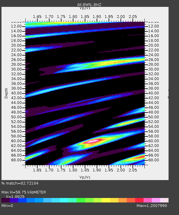
| Estimated Moho Depth: |
59.75 km |
| Estimated Crust Vp/Vs: |
1.88 |
| Assumed Crust Vp: |
6.566 km/s |
| Estimated Crust Vs: |
3.488 km/s |
| Estimated Crust Poisson's Ratio: |
0.30 |
|
| Radial Match: |
82.72184 % |
| Radial Bump: |
400 |
| Transverse Match: |
86.75619 % |
| Transverse Bump: |
400 |
| SOD ConfigId: |
21709731 |
| Insert Time: |
2020-07-20 18:17:15.055 +0000 |
| GWidth: |
2.5 |
| Max Bumps: |
400 |
| Tol: |
0.001 |
|

Signal To Noise
| Channel | StoN | STA | LTA |
| AK:BWN: :BHZ:20200706T18:27:03.308002Z | 8.111879 | 7.640119E-7 | 9.418432E-8 |
| AK:BWN: :BHN:20200706T18:27:03.308002Z | 2.3670585 | 2.3473376E-7 | 9.9166854E-8 |
| AK:BWN: :BHE:20200706T18:27:03.308002Z | 1.611851 | 3.8636622E-7 | 2.3970344E-7 |
| Arrivals |
| Ps | 8.3 SECOND |
| PpPs | 25 SECOND |
| PsPs/PpSs | 34 SECOND |


