You are here: Home > Network List > II - Global Seismograph Network (GSN - IRIS/IDA) Stations List
> Station CMLA Cha de Macela, Sao Miguel Island, Azores > Earthquake Result Viewer
CMLA Cha de Macela, Sao Miguel Island, Azores - Earthquake Result Viewer
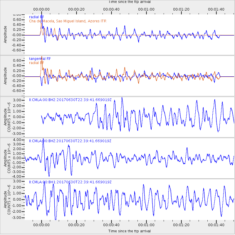
| Earthquake location: |
Near Coast Of Ecuador |
| Earthquake latitude/longitude: |
-0.3/-80.5 |
| Earthquake time(UTC): |
2017/06/30 (181) 22:29:44 GMT |
| Earthquake Depth: |
7.4 km |
| Earthquake Magnitude: |
6.0 Mww |
| Earthquake Catalog/Contributor: |
NEIC PDE/us |
|
| Network: |
II Global Seismograph Network (GSN - IRIS/IDA) |
| Station: |
CMLA Cha de Macela, Sao Miguel Island, Azores |
| Lat/Lon: |
37.76 N/25.52 W |
| Elevation: |
429 m |
|
| Distance: |
63.2 deg |
| Az: |
46.662 deg |
| Baz: |
246.593 deg |
| Ray Param: |
0.0597522 |
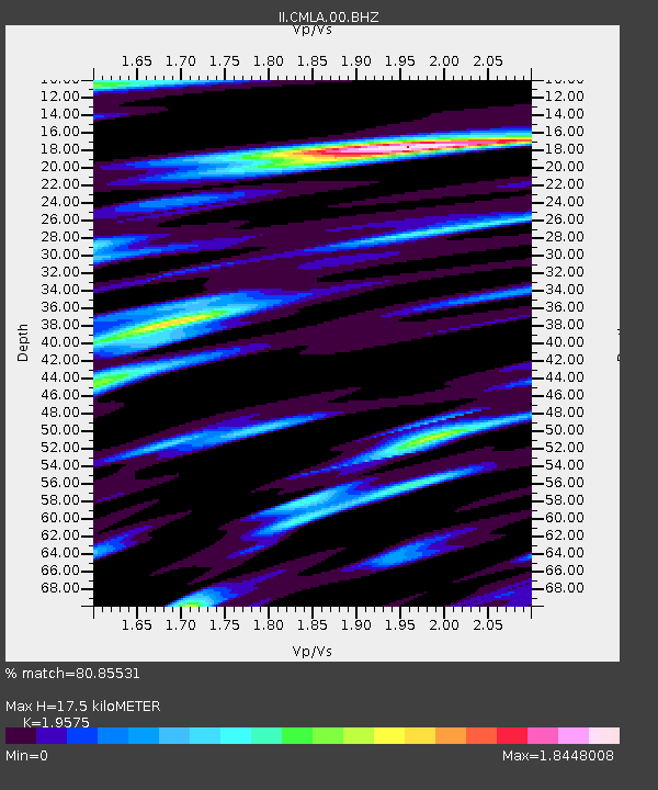
| Estimated Moho Depth: |
17.5 km |
| Estimated Crust Vp/Vs: |
1.96 |
| Assumed Crust Vp: |
4.802 km/s |
| Estimated Crust Vs: |
2.453 km/s |
| Estimated Crust Poisson's Ratio: |
0.32 |
|
| Radial Match: |
80.85531 % |
| Radial Bump: |
371 |
| Transverse Match: |
68.56756 % |
| Transverse Bump: |
394 |
| SOD ConfigId: |
2140511 |
| Insert Time: |
2017-07-14 14:23:26.318 +0000 |
| GWidth: |
2.5 |
| Max Bumps: |
400 |
| Tol: |
0.001 |
|
Signal To Noise
| Channel | StoN | STA | LTA |
| II:CMLA:00:BHZ:20170630T22:39:41.669019Z | 4.327159 | 2.1706744E-6 | 5.016396E-7 |
| II:CMLA:00:BH1:20170630T22:39:41.669019Z | 2.4726214 | 1.6046093E-6 | 6.489506E-7 |
| II:CMLA:00:BH2:20170630T22:39:41.669019Z | 2.6666436 | 1.268822E-6 | 4.7581236E-7 |
| Arrivals |
| Ps | 3.6 SECOND |
| PpPs | 11 SECOND |
| PsPs/PpSs | 14 SECOND |


