You are here: Home > Network List > IU - Global Seismograph Network (GSN - IRIS/USGS) Stations List
> Station CCM Cathedral Cave, Missouri, USA > Earthquake Result Viewer
CCM Cathedral Cave, Missouri, USA - Earthquake Result Viewer
| Earthquake location: |
Near Coast Of Ecuador |
| Earthquake latitude/longitude: |
-0.3/-80.5 |
| Earthquake time(UTC): |
2017/06/30 (181) 22:29:44 GMT |
| Earthquake Depth: |
7.4 km |
| Earthquake Magnitude: |
6.0 Mww |
| Earthquake Catalog/Contributor: |
NEIC PDE/us |
|
| Network: |
IU Global Seismograph Network (GSN - IRIS/USGS) |
| Station: |
CCM Cathedral Cave, Missouri, USA |
| Lat/Lon: |
38.06 N/91.24 W |
| Elevation: |
222 m |
|
| Distance: |
39.5 deg |
| Az: |
346.62 deg |
| Baz: |
162.954 deg |
| Ray Param: |
0.07497649 |
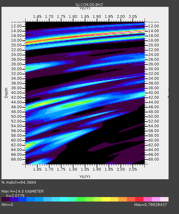
| Estimated Moho Depth: |
14.0 km |
| Estimated Crust Vp/Vs: |
2.08 |
| Assumed Crust Vp: |
6.498 km/s |
| Estimated Crust Vs: |
3.128 km/s |
| Estimated Crust Poisson's Ratio: |
0.35 |
|
| Radial Match: |
94.3684 % |
| Radial Bump: |
308 |
| Transverse Match: |
70.80757 % |
| Transverse Bump: |
400 |
| SOD ConfigId: |
2140511 |
| Insert Time: |
2017-07-14 14:23:35.049 +0000 |
| GWidth: |
2.5 |
| Max Bumps: |
400 |
| Tol: |
0.001 |
|

Signal To Noise
| Channel | StoN | STA | LTA |
| IU:CCM:00:BHZ:20170630T22:36:44.219006Z | 18.032272 | 1.0028398E-6 | 5.5613608E-8 |
| IU:CCM:00:BH1:20170630T22:36:44.219006Z | 15.008954 | 6.186417E-7 | 4.1218176E-8 |
| IU:CCM:00:BH2:20170630T22:36:44.219006Z | 1.5438362 | 1.0528642E-7 | 6.819792E-8 |
| Arrivals |
| Ps | 2.5 SECOND |
| PpPs | 6.2 SECOND |
| PsPs/PpSs | 8.7 SECOND |


