You are here: Home > Network List > AK - Alaska Regional Network Stations List
> Station O18K Koktuh Hills, AK, USA > Earthquake Result Viewer
O18K Koktuh Hills, AK, USA - Earthquake Result Viewer
| Earthquake location: |
W. Caroline Islands, Micronesia |
| Earthquake latitude/longitude: |
12.1/140.2 |
| Earthquake time(UTC): |
2020/07/06 (188) 18:16:18 GMT |
| Earthquake Depth: |
12 km |
| Earthquake Magnitude: |
6.2 mww |
| Earthquake Catalog/Contributor: |
NEIC PDE/us |
|
| Network: |
AK Alaska Regional Network |
| Station: |
O18K Koktuh Hills, AK, USA |
| Lat/Lon: |
59.85 N/155.21 W |
| Elevation: |
544 m |
|
| Distance: |
67.0 deg |
| Az: |
29.685 deg |
| Baz: |
253.704 deg |
| Ray Param: |
0.057262726 |
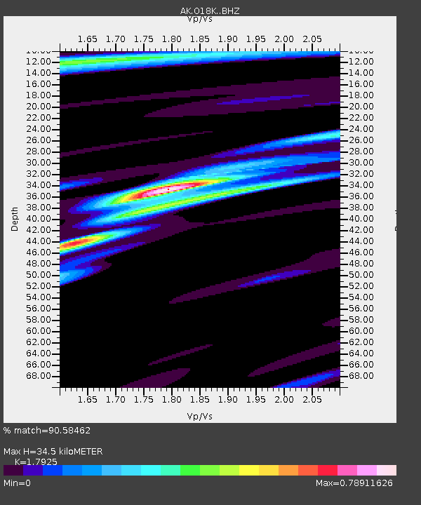
| Estimated Moho Depth: |
34.5 km |
| Estimated Crust Vp/Vs: |
1.79 |
| Assumed Crust Vp: |
6.438 km/s |
| Estimated Crust Vs: |
3.592 km/s |
| Estimated Crust Poisson's Ratio: |
0.27 |
|
| Radial Match: |
90.58462 % |
| Radial Bump: |
400 |
| Transverse Match: |
74.38421 % |
| Transverse Bump: |
400 |
| SOD ConfigId: |
21709731 |
| Insert Time: |
2020-07-20 18:18:41.628 +0000 |
| GWidth: |
2.5 |
| Max Bumps: |
400 |
| Tol: |
0.001 |
|

Signal To Noise
| Channel | StoN | STA | LTA |
| AK:O18K: :BHZ:20200706T18:26:39.860004Z | 6.796307 | 6.5035715E-7 | 9.569273E-8 |
| AK:O18K: :BHN:20200706T18:26:39.860004Z | 1.613004 | 1.1198089E-7 | 6.942381E-8 |
| AK:O18K: :BHE:20200706T18:26:39.860004Z | 3.67969 | 2.5984616E-7 | 7.061632E-8 |
| Arrivals |
| Ps | 4.4 SECOND |
| PpPs | 14 SECOND |
| PsPs/PpSs | 19 SECOND |


