You are here: Home > Network List > AK - Alaska Regional Network Stations List
> Station PPLA Purkeypile > Earthquake Result Viewer
PPLA Purkeypile - Earthquake Result Viewer
| Earthquake location: |
W. Caroline Islands, Micronesia |
| Earthquake latitude/longitude: |
12.1/140.2 |
| Earthquake time(UTC): |
2020/07/06 (188) 18:16:18 GMT |
| Earthquake Depth: |
12 km |
| Earthquake Magnitude: |
6.2 mww |
| Earthquake Catalog/Contributor: |
NEIC PDE/us |
|
| Network: |
AK Alaska Regional Network |
| Station: |
PPLA Purkeypile |
| Lat/Lon: |
62.90 N/152.19 W |
| Elevation: |
1519 m |
|
| Distance: |
69.2 deg |
| Az: |
26.932 deg |
| Baz: |
255.325 deg |
| Ray Param: |
0.055812947 |
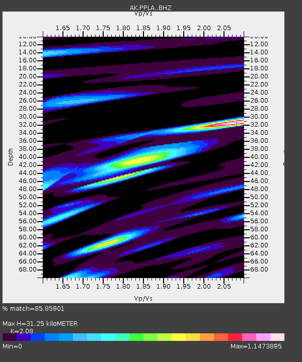
| Estimated Moho Depth: |
31.25 km |
| Estimated Crust Vp/Vs: |
2.08 |
| Assumed Crust Vp: |
6.566 km/s |
| Estimated Crust Vs: |
3.157 km/s |
| Estimated Crust Poisson's Ratio: |
0.35 |
|
| Radial Match: |
85.85901 % |
| Radial Bump: |
400 |
| Transverse Match: |
84.78877 % |
| Transverse Bump: |
400 |
| SOD ConfigId: |
21709731 |
| Insert Time: |
2020-07-20 18:18:51.089 +0000 |
| GWidth: |
2.5 |
| Max Bumps: |
400 |
| Tol: |
0.001 |
|

Signal To Noise
| Channel | StoN | STA | LTA |
| AK:PPLA: :BHZ:20200706T18:26:53.748005Z | 8.468873 | 6.4151027E-7 | 7.5749185E-8 |
| AK:PPLA: :BHN:20200706T18:26:53.748005Z | 1.4685816 | 1.347518E-7 | 9.175643E-8 |
| AK:PPLA: :BHE:20200706T18:26:53.748005Z | 3.2852094 | 2.7083718E-7 | 8.2441375E-8 |
| Arrivals |
| Ps | 5.3 SECOND |
| PpPs | 14 SECOND |
| PsPs/PpSs | 19 SECOND |


