You are here: Home > Network List > AT - Alaska Tsunami Warning Seismic System Stations List
> Station AKUT Akutan, Alaska > Earthquake Result Viewer
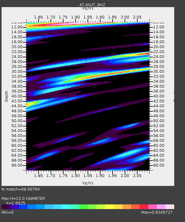
AKUT Akutan, Alaska - Earthquake Result Viewer
| Earthquake location: |
W. Caroline Islands, Micronesia |
| Earthquake latitude/longitude: |
12.1/140.2 |
| Earthquake time(UTC): |
2020/07/06 (188) 18:16:18 GMT |
| Earthquake Depth: |
12 km |
| Earthquake Magnitude: |
6.2 mww |
| Earthquake Catalog/Contributor: |
NEIC PDE/us |
|
| Network: |
AT Alaska Tsunami Warning Seismic System |
| Station: |
AKUT Akutan, Alaska |
| Lat/Lon: |
54.14 N/165.77 W |
| Elevation: |
19 m |
|
| Distance: |
59.6 deg |
| Az: |
33.499 deg |
| Baz: |
246.564 deg |
| Ray Param: |
0.062085744 |
| Estimated Moho Depth: |
10.0 km |
| Estimated Crust Vp/Vs: |
1.85 |
| Assumed Crust Vp: |
5.989 km/s |
| Estimated Crust Vs: |
3.233 km/s |
| Estimated Crust Poisson's Ratio: |
0.29 |
|
| Radial Match: |
86.58794 % |
| Radial Bump: |
400 |
| Transverse Match: |
76.668106 % |
| Transverse Bump: |
400 |
| SOD ConfigId: |
21709731 |
| Insert Time: |
2020-07-20 18:19:48.785 +0000 |
| GWidth: |
2.5 |
| Max Bumps: |
400 |
| Tol: |
0.001 |
|

Signal To Noise
| Channel | StoN | STA | LTA |
| AT:AKUT: :BHZ:20200706T18:25:51.060017Z | 6.2043147 | 1.3217019E-6 | 2.1302948E-7 |
| AT:AKUT: :BHN:20200706T18:25:51.060017Z | 1.3952432 | 3.00759E-7 | 2.1556029E-7 |
| AT:AKUT: :BHE:20200706T18:25:51.060017Z | 2.7465746 | 4.2046358E-7 | 1.5308653E-7 |
| Arrivals |
| Ps | 1.5 SECOND |
| PpPs | 4.6 SECOND |
| PsPs/PpSs | 6.1 SECOND |


