You are here: Home > Network List > AV - Alaska Volcano Observatory Stations List
> Station AKHS Akutan Broiad Bright, Akutan Volcano, Alaska > Earthquake Result Viewer
AKHS Akutan Broiad Bright, Akutan Volcano, Alaska - Earthquake Result Viewer
| Earthquake location: |
W. Caroline Islands, Micronesia |
| Earthquake latitude/longitude: |
12.1/140.2 |
| Earthquake time(UTC): |
2020/07/06 (188) 18:16:18 GMT |
| Earthquake Depth: |
12 km |
| Earthquake Magnitude: |
6.2 mww |
| Earthquake Catalog/Contributor: |
NEIC PDE/us |
|
| Network: |
AV Alaska Volcano Observatory |
| Station: |
AKHS Akutan Broiad Bright, Akutan Volcano, Alaska |
| Lat/Lon: |
54.15 N/165.89 W |
| Elevation: |
150 m |
|
| Distance: |
59.5 deg |
| Az: |
33.449 deg |
| Baz: |
246.445 deg |
| Ray Param: |
0.062123053 |
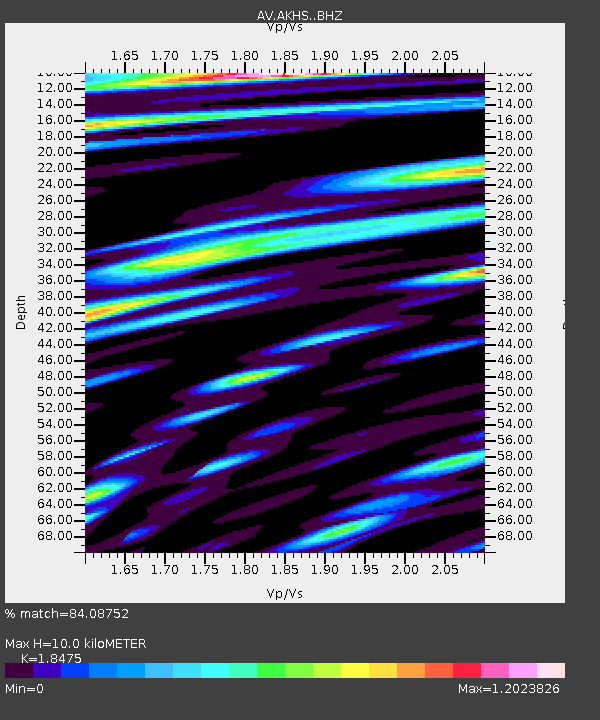
| Estimated Moho Depth: |
10.0 km |
| Estimated Crust Vp/Vs: |
1.85 |
| Assumed Crust Vp: |
5.989 km/s |
| Estimated Crust Vs: |
3.242 km/s |
| Estimated Crust Poisson's Ratio: |
0.29 |
|
| Radial Match: |
84.08752 % |
| Radial Bump: |
400 |
| Transverse Match: |
82.76036 % |
| Transverse Bump: |
400 |
| SOD ConfigId: |
21709731 |
| Insert Time: |
2020-07-20 18:20:34.580 +0000 |
| GWidth: |
2.5 |
| Max Bumps: |
400 |
| Tol: |
0.001 |
|

Signal To Noise
| Channel | StoN | STA | LTA |
| AV:AKHS: :BHZ:20200706T18:25:50.680012Z | 6.639798 | 6.215443E-7 | 9.360891E-8 |
| AV:AKHS: :BHN:20200706T18:25:50.680012Z | 2.6256223 | 4.8859573E-7 | 1.8608759E-7 |
| AV:AKHS: :BHE:20200706T18:25:50.680012Z | 2.437285 | 3.3283308E-7 | 1.3655895E-7 |
| Arrivals |
| Ps | 1.5 SECOND |
| PpPs | 4.6 SECOND |
| PsPs/PpSs | 6.0 SECOND |


