You are here: Home > Network List > AV - Alaska Volcano Observatory Stations List
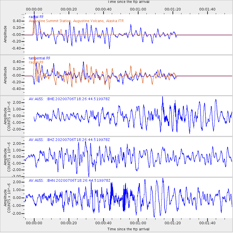
> Station AUSS Augustine Summit Station, Augustine Volcano, Alaska > Earthquake Result Viewer
AUSS Augustine Summit Station, Augustine Volcano, Alaska - Earthquake Result Viewer
| Earthquake location: |
W. Caroline Islands, Micronesia |
| Earthquake latitude/longitude: |
12.1/140.2 |
| Earthquake time(UTC): |
2020/07/06 (188) 18:16:18 GMT |
| Earthquake Depth: |
12 km |
| Earthquake Magnitude: |
6.2 mww |
| Earthquake Catalog/Contributor: |
NEIC PDE/us |
|
| Network: |
AV Alaska Volcano Observatory |
| Station: |
AUSS Augustine Summit Station, Augustine Volcano, Alaska |
| Lat/Lon: |
59.36 N/153.43 W |
| Elevation: |
1235 m |
|
| Distance: |
67.7 deg |
| Az: |
30.464 deg |
| Baz: |
255.535 deg |
| Ray Param: |
0.056789372 |
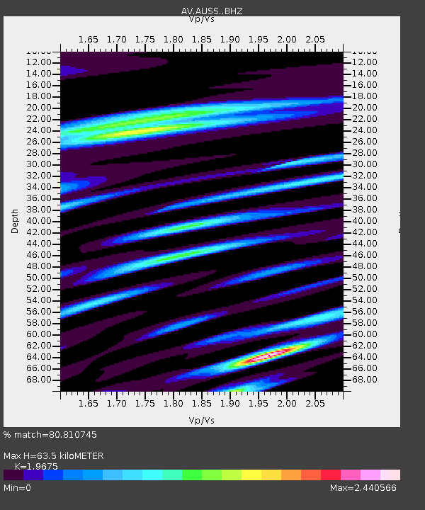
| Estimated Moho Depth: |
63.5 km |
| Estimated Crust Vp/Vs: |
1.97 |
| Assumed Crust Vp: |
5.989 km/s |
| Estimated Crust Vs: |
3.044 km/s |
| Estimated Crust Poisson's Ratio: |
0.33 |
|
| Radial Match: |
80.810745 % |
| Radial Bump: |
400 |
| Transverse Match: |
83.26107 % |
| Transverse Bump: |
293 |
| SOD ConfigId: |
21709731 |
| Insert Time: |
2020-07-20 18:20:51.268 +0000 |
| GWidth: |
2.5 |
| Max Bumps: |
400 |
| Tol: |
0.001 |
|
Signal To Noise
| Channel | StoN | STA | LTA |
| AV:AUSS: :BHZ:20200706T18:26:44.519978Z | 3.2915988 | 6.9698973E-7 | 2.1174809E-7 |
| AV:AUSS: :BHN:20200706T18:26:44.519978Z | 1.3593999 | 4.688678E-7 | 3.4490793E-7 |
| AV:AUSS: :BHE:20200706T18:26:44.519978Z | 1.290052 | 5.163234E-7 | 4.0023454E-7 |
| Arrivals |
| Ps | 11 SECOND |
| PpPs | 31 SECOND |
| PsPs/PpSs | 41 SECOND |


