You are here: Home > Network List > AV - Alaska Volcano Observatory Stations List
> Station ETKA Kagalaska Island, Regional Station, Alaska > Earthquake Result Viewer
ETKA Kagalaska Island, Regional Station, Alaska - Earthquake Result Viewer
| Earthquake location: |
W. Caroline Islands, Micronesia |
| Earthquake latitude/longitude: |
12.1/140.2 |
| Earthquake time(UTC): |
2020/07/06 (188) 18:16:18 GMT |
| Earthquake Depth: |
12 km |
| Earthquake Magnitude: |
6.2 mww |
| Earthquake Catalog/Contributor: |
NEIC PDE/us |
|
| Network: |
AV Alaska Volcano Observatory |
| Station: |
ETKA Kagalaska Island, Regional Station, Alaska |
| Lat/Lon: |
51.86 N/176.41 W |
| Elevation: |
290 m |
|
| Distance: |
52.8 deg |
| Az: |
32.281 deg |
| Baz: |
237.401 deg |
| Ray Param: |
0.0664946 |
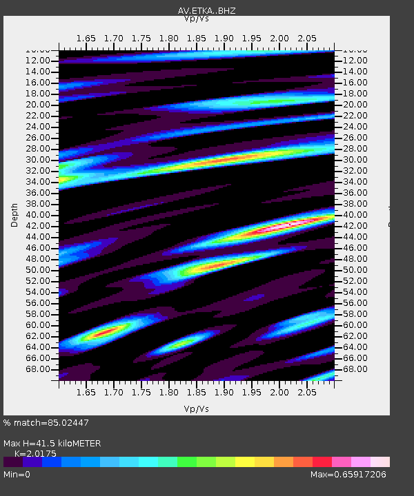
| Estimated Moho Depth: |
41.5 km |
| Estimated Crust Vp/Vs: |
2.02 |
| Assumed Crust Vp: |
5.88 km/s |
| Estimated Crust Vs: |
2.915 km/s |
| Estimated Crust Poisson's Ratio: |
0.34 |
|
| Radial Match: |
85.02447 % |
| Radial Bump: |
400 |
| Transverse Match: |
75.32867 % |
| Transverse Bump: |
398 |
| SOD ConfigId: |
21709731 |
| Insert Time: |
2020-07-20 18:20:59.373 +0000 |
| GWidth: |
2.5 |
| Max Bumps: |
400 |
| Tol: |
0.001 |
|

Signal To Noise
| Channel | StoN | STA | LTA |
| AV:ETKA: :BHZ:20200706T18:25:03.039021Z | 6.3956003 | 7.124289E-7 | 1.1139359E-7 |
| AV:ETKA: :BHN:20200706T18:25:03.039021Z | 1.8503209 | 2.551305E-7 | 1.3788446E-7 |
| AV:ETKA: :BHE:20200706T18:25:03.039021Z | 2.1316776 | 3.1722425E-7 | 1.4881437E-7 |
| Arrivals |
| Ps | 7.5 SECOND |
| PpPs | 20 SECOND |
| PsPs/PpSs | 28 SECOND |


