You are here: Home > Network List > AV - Alaska Volcano Observatory Stations List
> Station GSCK Cape Kiugilak, Great Sitkin Volcano, Alaska > Earthquake Result Viewer
GSCK Cape Kiugilak, Great Sitkin Volcano, Alaska - Earthquake Result Viewer
| Earthquake location: |
W. Caroline Islands, Micronesia |
| Earthquake latitude/longitude: |
12.1/140.2 |
| Earthquake time(UTC): |
2020/07/06 (188) 18:16:18 GMT |
| Earthquake Depth: |
12 km |
| Earthquake Magnitude: |
6.2 mww |
| Earthquake Catalog/Contributor: |
NEIC PDE/us |
|
| Network: |
AV Alaska Volcano Observatory |
| Station: |
GSCK Cape Kiugilak, Great Sitkin Volcano, Alaska |
| Lat/Lon: |
52.01 N/176.16 W |
| Elevation: |
384 m |
|
| Distance: |
53.1 deg |
| Az: |
32.224 deg |
| Baz: |
237.558 deg |
| Ray Param: |
0.066361666 |
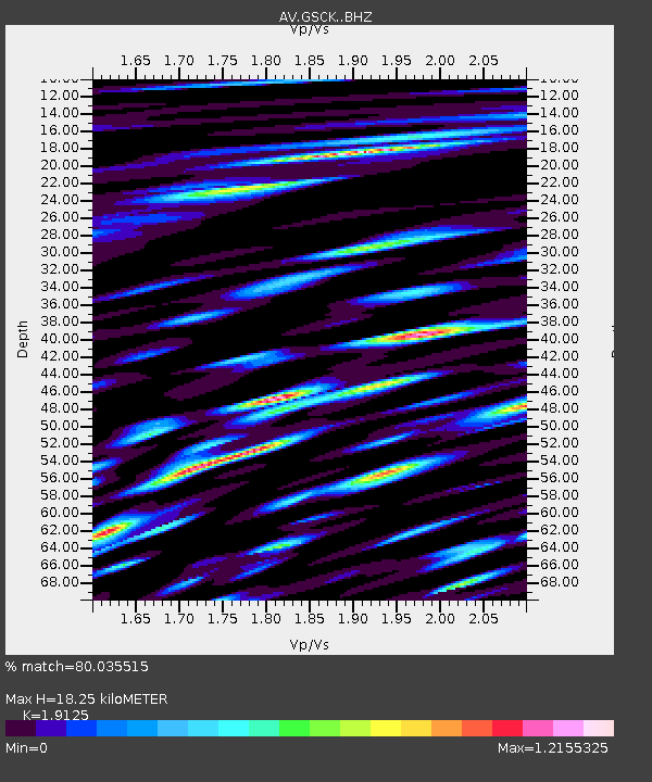
| Estimated Moho Depth: |
18.25 km |
| Estimated Crust Vp/Vs: |
1.91 |
| Assumed Crust Vp: |
3.912 km/s |
| Estimated Crust Vs: |
2.045 km/s |
| Estimated Crust Poisson's Ratio: |
0.31 |
|
| Radial Match: |
80.035515 % |
| Radial Bump: |
400 |
| Transverse Match: |
63.36169 % |
| Transverse Bump: |
400 |
| SOD ConfigId: |
21709731 |
| Insert Time: |
2020-07-20 18:21:07.835 +0000 |
| GWidth: |
2.5 |
| Max Bumps: |
400 |
| Tol: |
0.001 |
|

Signal To Noise
| Channel | StoN | STA | LTA |
| AV:GSCK: :BHZ:20200706T18:25:04.579975Z | 3.262778 | 5.443465E-7 | 1.6683529E-7 |
| AV:GSCK: :BHN:20200706T18:25:04.579975Z | 1.2954721 | 2.9524E-7 | 2.2790147E-7 |
| AV:GSCK: :BHE:20200706T18:25:04.579975Z | 2.256945 | 5.57913E-7 | 2.471983E-7 |
| Arrivals |
| Ps | 4.3 SECOND |
| PpPs | 13 SECOND |
| PsPs/PpSs | 18 SECOND |


