You are here: Home > Network List > AV - Alaska Volcano Observatory Stations List
> Station ILSW Iliamna Southwest, Iliamna Volcano, Alaska > Earthquake Result Viewer
ILSW Iliamna Southwest, Iliamna Volcano, Alaska - Earthquake Result Viewer
| Earthquake location: |
W. Caroline Islands, Micronesia |
| Earthquake latitude/longitude: |
12.1/140.2 |
| Earthquake time(UTC): |
2020/07/06 (188) 18:16:18 GMT |
| Earthquake Depth: |
12 km |
| Earthquake Magnitude: |
6.2 mww |
| Earthquake Catalog/Contributor: |
NEIC PDE/us |
|
| Network: |
AV Alaska Volcano Observatory |
| Station: |
ILSW Iliamna Southwest, Iliamna Volcano, Alaska |
| Lat/Lon: |
59.98 N/153.14 W |
| Elevation: |
1318 m |
|
| Distance: |
68.0 deg |
| Az: |
29.848 deg |
| Baz: |
255.551 deg |
| Ray Param: |
0.05658797 |
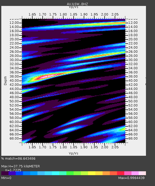
| Estimated Moho Depth: |
37.75 km |
| Estimated Crust Vp/Vs: |
1.72 |
| Assumed Crust Vp: |
5.989 km/s |
| Estimated Crust Vs: |
3.477 km/s |
| Estimated Crust Poisson's Ratio: |
0.25 |
|
| Radial Match: |
86.643486 % |
| Radial Bump: |
400 |
| Transverse Match: |
78.302795 % |
| Transverse Bump: |
400 |
| SOD ConfigId: |
21709731 |
| Insert Time: |
2020-07-20 18:21:19.002 +0000 |
| GWidth: |
2.5 |
| Max Bumps: |
400 |
| Tol: |
0.001 |
|
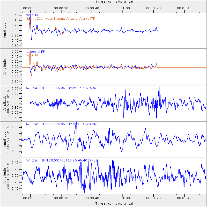
Signal To Noise
| Channel | StoN | STA | LTA |
| AV:ILSW: :BHZ:20200706T18:26:46.407978Z | 5.0658984 | 4.2119837E-7 | 8.314387E-8 |
| AV:ILSW: :BHN:20200706T18:26:46.407978Z | 1.8527898 | 1.6475944E-7 | 8.892506E-8 |
| AV:ILSW: :BHE:20200706T18:26:46.407978Z | 1.8138508 | 1.9099838E-7 | 1.0529995E-7 |
| Arrivals |
| Ps | 4.7 SECOND |
| PpPs | 17 SECOND |
| PsPs/PpSs | 21 SECOND |


