You are here: Home > Network List > AV - Alaska Volcano Observatory Stations List
> Station MNAT Nateekin Bay, Makushin Volcano, Alaska > Earthquake Result Viewer
MNAT Nateekin Bay, Makushin Volcano, Alaska - Earthquake Result Viewer
| Earthquake location: |
W. Caroline Islands, Micronesia |
| Earthquake latitude/longitude: |
12.1/140.2 |
| Earthquake time(UTC): |
2020/07/06 (188) 18:16:18 GMT |
| Earthquake Depth: |
12 km |
| Earthquake Magnitude: |
6.2 mww |
| Earthquake Catalog/Contributor: |
NEIC PDE/us |
|
| Network: |
AV Alaska Volcano Observatory |
| Station: |
MNAT Nateekin Bay, Makushin Volcano, Alaska |
| Lat/Lon: |
53.88 N/166.69 W |
| Elevation: |
390 m |
|
| Distance: |
59.0 deg |
| Az: |
33.515 deg |
| Baz: |
245.834 deg |
| Ray Param: |
0.062479265 |
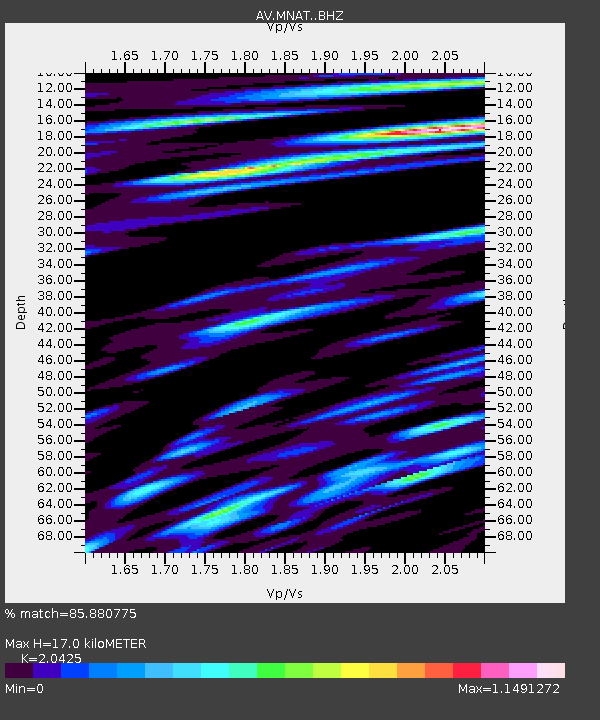
| Estimated Moho Depth: |
17.0 km |
| Estimated Crust Vp/Vs: |
2.04 |
| Assumed Crust Vp: |
3.943 km/s |
| Estimated Crust Vs: |
1.931 km/s |
| Estimated Crust Poisson's Ratio: |
0.34 |
|
| Radial Match: |
85.880775 % |
| Radial Bump: |
400 |
| Transverse Match: |
80.01169 % |
| Transverse Bump: |
400 |
| SOD ConfigId: |
21709731 |
| Insert Time: |
2020-07-20 18:21:50.972 +0000 |
| GWidth: |
2.5 |
| Max Bumps: |
400 |
| Tol: |
0.001 |
|
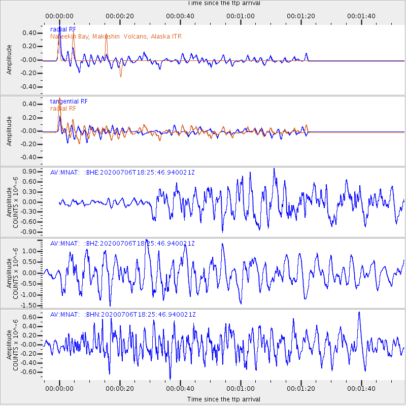
Signal To Noise
| Channel | StoN | STA | LTA |
| AV:MNAT: :BHZ:20200706T18:25:46.940021Z | 7.7408347 | 5.640845E-7 | 7.287127E-8 |
| AV:MNAT: :BHN:20200706T18:25:46.940021Z | 1.1145344 | 1.0868612E-7 | 9.7517066E-8 |
| AV:MNAT: :BHE:20200706T18:25:46.940021Z | 4.230303 | 2.7980948E-7 | 6.6144075E-8 |
| Arrivals |
| Ps | 4.6 SECOND |
| PpPs | 13 SECOND |
| PsPs/PpSs | 17 SECOND |


