You are here: Home > Network List > AV - Alaska Volcano Observatory Stations List
> Station RDT Redoubt, Alaska > Earthquake Result Viewer
RDT Redoubt, Alaska - Earthquake Result Viewer
| Earthquake location: |
W. Caroline Islands, Micronesia |
| Earthquake latitude/longitude: |
12.1/140.2 |
| Earthquake time(UTC): |
2020/07/06 (188) 18:16:18 GMT |
| Earthquake Depth: |
12 km |
| Earthquake Magnitude: |
6.2 mww |
| Earthquake Catalog/Contributor: |
NEIC PDE/us |
|
| Network: |
AV Alaska Volcano Observatory |
| Station: |
RDT Redoubt, Alaska |
| Lat/Lon: |
60.57 N/152.41 W |
| Elevation: |
930 m |
|
| Distance: |
68.5 deg |
| Az: |
29.328 deg |
| Baz: |
255.996 deg |
| Ray Param: |
0.05625457 |
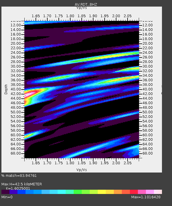
| Estimated Moho Depth: |
42.5 km |
| Estimated Crust Vp/Vs: |
1.60 |
| Assumed Crust Vp: |
6.566 km/s |
| Estimated Crust Vs: |
4.097 km/s |
| Estimated Crust Poisson's Ratio: |
0.18 |
|
| Radial Match: |
83.94761 % |
| Radial Bump: |
400 |
| Transverse Match: |
75.907265 % |
| Transverse Bump: |
400 |
| SOD ConfigId: |
21709731 |
| Insert Time: |
2020-07-20 18:22:05.069 +0000 |
| GWidth: |
2.5 |
| Max Bumps: |
400 |
| Tol: |
0.001 |
|

Signal To Noise
| Channel | StoN | STA | LTA |
| AV:RDT: :BHZ:20200706T18:26:49.539997Z | 6.257931 | 3.066776E-7 | 4.9006225E-8 |
| AV:RDT: :BHN:20200706T18:26:49.539997Z | 1.3362733 | 8.137104E-8 | 6.089401E-8 |
| AV:RDT: :BHE:20200706T18:26:49.539997Z | 2.7900312 | 1.4005684E-7 | 5.019902E-8 |
| Arrivals |
| Ps | 4.1 SECOND |
| PpPs | 16 SECOND |
| PsPs/PpSs | 20 SECOND |


