You are here: Home > Network List > AV - Alaska Volcano Observatory Stations List
> Station WAZA Wrangell Zanetti, Alaska > Earthquake Result Viewer
WAZA Wrangell Zanetti, Alaska - Earthquake Result Viewer
| Earthquake location: |
W. Caroline Islands, Micronesia |
| Earthquake latitude/longitude: |
12.1/140.2 |
| Earthquake time(UTC): |
2020/07/06 (188) 18:16:18 GMT |
| Earthquake Depth: |
12 km |
| Earthquake Magnitude: |
6.2 mww |
| Earthquake Catalog/Contributor: |
NEIC PDE/us |
|
| Network: |
AV Alaska Volcano Observatory |
| Station: |
WAZA Wrangell Zanetti, Alaska |
| Lat/Lon: |
62.07 N/144.15 W |
| Elevation: |
2531 m |
|
| Distance: |
72.7 deg |
| Az: |
28.531 deg |
| Baz: |
262.964 deg |
| Ray Param: |
0.0535041 |
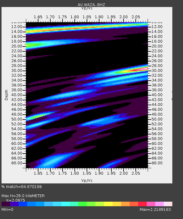
| Estimated Moho Depth: |
29.0 km |
| Estimated Crust Vp/Vs: |
2.10 |
| Assumed Crust Vp: |
6.566 km/s |
| Estimated Crust Vs: |
3.13 km/s |
| Estimated Crust Poisson's Ratio: |
0.35 |
|
| Radial Match: |
84.870186 % |
| Radial Bump: |
400 |
| Transverse Match: |
86.29926 % |
| Transverse Bump: |
400 |
| SOD ConfigId: |
21709731 |
| Insert Time: |
2020-07-20 18:22:28.250 +0000 |
| GWidth: |
2.5 |
| Max Bumps: |
400 |
| Tol: |
0.001 |
|

Signal To Noise
| Channel | StoN | STA | LTA |
| AV:WAZA: :BHZ:20200706T18:27:14.980Z | 7.037154 | 5.0926985E-7 | 7.236872E-8 |
| AV:WAZA: :BHN:20200706T18:27:14.980Z | 1.684377 | 1.10171875E-7 | 6.540809E-8 |
| AV:WAZA: :BHE:20200706T18:27:14.980Z | 3.4791026 | 2.586122E-7 | 7.4333016E-8 |
| Arrivals |
| Ps | 5.0 SECOND |
| PpPs | 13 SECOND |
| PsPs/PpSs | 18 SECOND |


