You are here: Home > Network List > AV - Alaska Volcano Observatory Stations List
> Station P19K Oil Pt, AK, USA > Earthquake Result Viewer
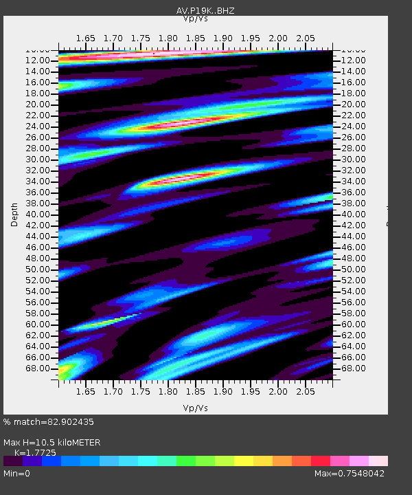
P19K Oil Pt, AK, USA - Earthquake Result Viewer
| Earthquake location: |
W. Caroline Islands, Micronesia |
| Earthquake latitude/longitude: |
12.1/140.2 |
| Earthquake time(UTC): |
2020/07/06 (188) 18:16:18 GMT |
| Earthquake Depth: |
12 km |
| Earthquake Magnitude: |
6.2 mww |
| Earthquake Catalog/Contributor: |
NEIC PDE/us |
|
| Network: |
AV Alaska Volcano Observatory |
| Station: |
P19K Oil Pt, AK, USA |
| Lat/Lon: |
59.65 N/153.23 W |
| Elevation: |
629 m |
|
| Distance: |
67.9 deg |
| Az: |
30.183 deg |
| Baz: |
255.6 deg |
| Ray Param: |
0.056673903 |
| Estimated Moho Depth: |
10.5 km |
| Estimated Crust Vp/Vs: |
1.77 |
| Assumed Crust Vp: |
5.989 km/s |
| Estimated Crust Vs: |
3.379 km/s |
| Estimated Crust Poisson's Ratio: |
0.27 |
|
| Radial Match: |
82.902435 % |
| Radial Bump: |
400 |
| Transverse Match: |
73.88832 % |
| Transverse Bump: |
400 |
| SOD ConfigId: |
21709731 |
| Insert Time: |
2020-07-20 18:22:35.022 +0000 |
| GWidth: |
2.5 |
| Max Bumps: |
400 |
| Tol: |
0.001 |
|

Signal To Noise
| Channel | StoN | STA | LTA |
| AV:P19K: :BHZ:20200706T18:26:45.599995Z | 5.9956627 | 8.093501E-7 | 1.3498926E-7 |
| AV:P19K: :BHN:20200706T18:26:45.599995Z | 1.3145646 | 1.4799984E-7 | 1.1258469E-7 |
| AV:P19K: :BHE:20200706T18:26:45.599995Z | 2.4040513 | 3.0817662E-7 | 1.2819054E-7 |
| Arrivals |
| Ps | 1.4 SECOND |
| PpPs | 4.7 SECOND |
| PsPs/PpSs | 6.1 SECOND |


