You are here: Home > Network List > CC - Cascade Chain Volcano Monitoring Stations List
> Station SIFT Swift Creek > Earthquake Result Viewer
SIFT Swift Creek - Earthquake Result Viewer
| Earthquake location: |
W. Caroline Islands, Micronesia |
| Earthquake latitude/longitude: |
12.1/140.2 |
| Earthquake time(UTC): |
2020/07/06 (188) 18:16:18 GMT |
| Earthquake Depth: |
12 km |
| Earthquake Magnitude: |
6.2 mww |
| Earthquake Catalog/Contributor: |
NEIC PDE/us |
|
| Network: |
CC Cascade Chain Volcano Monitoring |
| Station: |
SIFT Swift Creek |
| Lat/Lon: |
46.87 N/121.95 W |
| Elevation: |
732 m |
|
| Distance: |
86.6 deg |
| Az: |
42.922 deg |
| Baz: |
283.851 deg |
| Ray Param: |
0.043954156 |
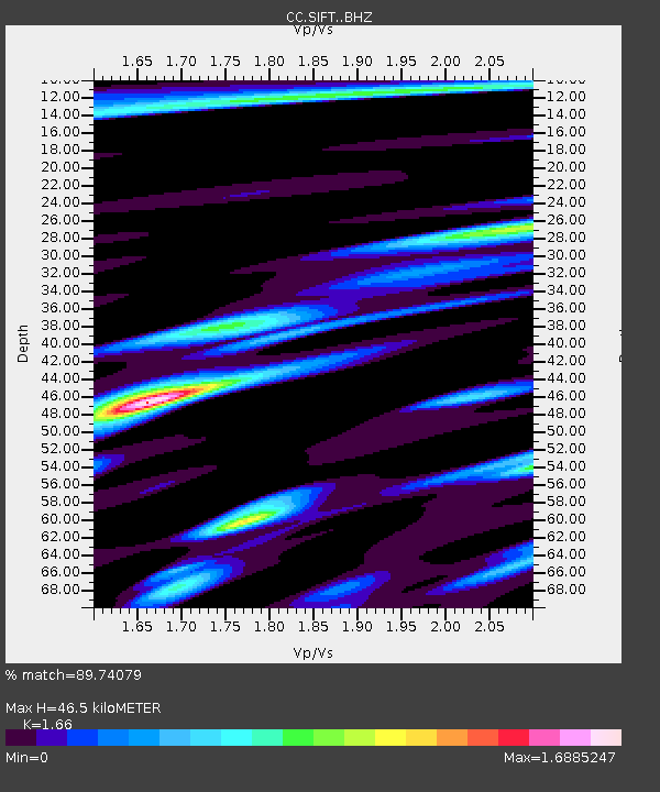
| Estimated Moho Depth: |
46.5 km |
| Estimated Crust Vp/Vs: |
1.66 |
| Assumed Crust Vp: |
6.597 km/s |
| Estimated Crust Vs: |
3.974 km/s |
| Estimated Crust Poisson's Ratio: |
0.22 |
|
| Radial Match: |
89.74079 % |
| Radial Bump: |
400 |
| Transverse Match: |
82.3954 % |
| Transverse Bump: |
400 |
| SOD ConfigId: |
21709731 |
| Insert Time: |
2020-07-20 18:23:48.565 +0000 |
| GWidth: |
2.5 |
| Max Bumps: |
400 |
| Tol: |
0.001 |
|

Signal To Noise
| Channel | StoN | STA | LTA |
| CC:SIFT: :BHZ:20200706T18:28:30.099995Z | 2.6890302 | 2.1753691E-7 | 8.0897905E-8 |
| CC:SIFT: :BHN:20200706T18:28:30.099995Z | 1.0313818 | 6.7355565E-8 | 6.530614E-8 |
| CC:SIFT: :BHE:20200706T18:28:30.099995Z | 1.357786 | 1.0017849E-7 | 7.378076E-8 |
| Arrivals |
| Ps | 4.8 SECOND |
| PpPs | 18 SECOND |
| PsPs/PpSs | 23 SECOND |


