You are here: Home > Network List > CC - Cascade Chain Volcano Monitoring Stations List
> Station WIZ Crater Lake, Wizard Island, OR > Earthquake Result Viewer
WIZ Crater Lake, Wizard Island, OR - Earthquake Result Viewer
| Earthquake location: |
W. Caroline Islands, Micronesia |
| Earthquake latitude/longitude: |
12.1/140.2 |
| Earthquake time(UTC): |
2020/07/06 (188) 18:16:18 GMT |
| Earthquake Depth: |
12 km |
| Earthquake Magnitude: |
6.2 mww |
| Earthquake Catalog/Contributor: |
NEIC PDE/us |
|
| Network: |
CC Cascade Chain Volcano Monitoring |
| Station: |
WIZ Crater Lake, Wizard Island, OR |
| Lat/Lon: |
42.93 N/122.15 W |
| Elevation: |
1884 m |
|
| Distance: |
87.4 deg |
| Az: |
46.779 deg |
| Baz: |
283.916 deg |
| Ray Param: |
0.04336345 |
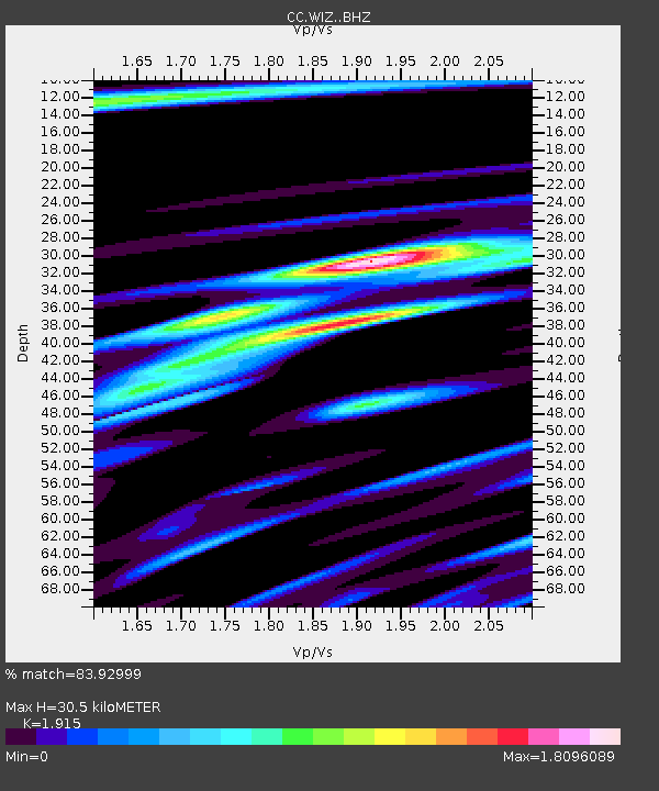
| Estimated Moho Depth: |
30.5 km |
| Estimated Crust Vp/Vs: |
1.91 |
| Assumed Crust Vp: |
6.522 km/s |
| Estimated Crust Vs: |
3.406 km/s |
| Estimated Crust Poisson's Ratio: |
0.31 |
|
| Radial Match: |
83.92999 % |
| Radial Bump: |
400 |
| Transverse Match: |
79.73674 % |
| Transverse Bump: |
400 |
| SOD ConfigId: |
21709731 |
| Insert Time: |
2020-07-20 18:23:57.552 +0000 |
| GWidth: |
2.5 |
| Max Bumps: |
400 |
| Tol: |
0.001 |
|

Signal To Noise
| Channel | StoN | STA | LTA |
| CC:WIZ: :BHZ:20200706T18:28:34.010029Z | 2.6430151 | 2.562464E-7 | 9.6952306E-8 |
| CC:WIZ: :BHN:20200706T18:28:34.010029Z | 0.36459348 | 4.7654755E-8 | 1.3070655E-7 |
| CC:WIZ: :BHE:20200706T18:28:34.010029Z | 1.564483 | 2.5588517E-7 | 1.6355894E-7 |
| Arrivals |
| Ps | 4.4 SECOND |
| PpPs | 13 SECOND |
| PsPs/PpSs | 18 SECOND |


