You are here: Home > Network List > CI - Caltech Regional Seismic Network Stations List
> Station GLA Glamis, Glamis, CA, USA > Earthquake Result Viewer
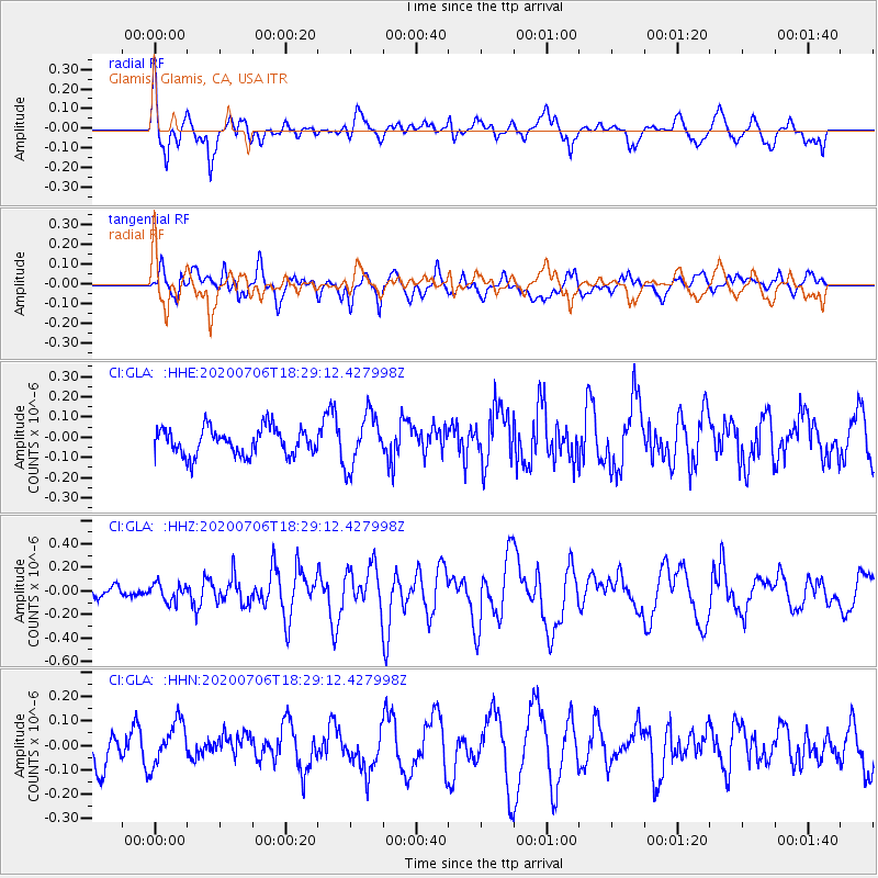
GLA Glamis, Glamis, CA, USA - Earthquake Result Viewer
*The percent match for this event was below the threshold and hence no stack was calculated.
| Earthquake location: |
W. Caroline Islands, Micronesia |
| Earthquake latitude/longitude: |
12.1/140.2 |
| Earthquake time(UTC): |
2020/07/06 (188) 18:16:18 GMT |
| Earthquake Depth: |
12 km |
| Earthquake Magnitude: |
6.2 mww |
| Earthquake Catalog/Contributor: |
NEIC PDE/us |
|
| Network: |
CI Caltech Regional Seismic Network |
| Station: |
GLA Glamis, Glamis, CA, USA |
| Lat/Lon: |
33.05 N/114.83 W |
| Elevation: |
610 m |
|
| Distance: |
95.7 deg |
| Az: |
54.638 deg |
| Baz: |
288.215 deg |
| Ray Param: |
$rayparam |
*The percent match for this event was below the threshold and hence was not used in the summary stack. |
|
| Radial Match: |
74.26414 % |
| Radial Bump: |
400 |
| Transverse Match: |
54.176296 % |
| Transverse Bump: |
400 |
| SOD ConfigId: |
21709731 |
| Insert Time: |
2020-07-20 18:24:17.114 +0000 |
| GWidth: |
2.5 |
| Max Bumps: |
400 |
| Tol: |
0.001 |
|
Signal To Noise
| Channel | StoN | STA | LTA |
| CI:GLA: :HHZ:20200706T18:29:12.427998Z | 1.8588787 | 7.643425E-8 | 4.111847E-8 |
| CI:GLA: :HHN:20200706T18:29:12.427998Z | 1.6766087 | 9.48955E-8 | 5.659967E-8 |
| CI:GLA: :HHE:20200706T18:29:12.427998Z | 1.9249727 | 1.2874152E-7 | 6.6879664E-8 |
| Arrivals |
| Ps | |
| PpPs | |
| PsPs/PpSs | |


