You are here: Home > Network List > G - GEOSCOPE Stations List
> Station RER Riviere de l'Est, La Reunion (Indian Ocean) > Earthquake Result Viewer
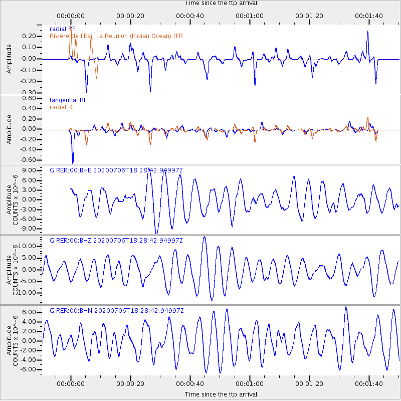
RER Riviere de l'Est, La Reunion (Indian Ocean) - Earthquake Result Viewer
*The percent match for this event was below the threshold and hence no stack was calculated.
| Earthquake location: |
W. Caroline Islands, Micronesia |
| Earthquake latitude/longitude: |
12.1/140.2 |
| Earthquake time(UTC): |
2020/07/06 (188) 18:16:18 GMT |
| Earthquake Depth: |
12 km |
| Earthquake Magnitude: |
6.2 mww |
| Earthquake Catalog/Contributor: |
NEIC PDE/us |
|
| Network: |
G GEOSCOPE |
| Station: |
RER Riviere de l'Est, La Reunion (Indian Ocean) |
| Lat/Lon: |
21.16 S/55.75 E |
| Elevation: |
834 m |
|
| Distance: |
89.3 deg |
| Az: |
248.307 deg |
| Baz: |
76.86 deg |
| Ray Param: |
$rayparam |
*The percent match for this event was below the threshold and hence was not used in the summary stack. |
|
| Radial Match: |
43.733078 % |
| Radial Bump: |
211 |
| Transverse Match: |
59.291187 % |
| Transverse Bump: |
282 |
| SOD ConfigId: |
21709731 |
| Insert Time: |
2020-07-20 18:26:35.584 +0000 |
| GWidth: |
2.5 |
| Max Bumps: |
400 |
| Tol: |
0.001 |
|
Signal To Noise
| Channel | StoN | STA | LTA |
| G:RER:00:BHZ:20200706T18:28:42.94997Z | 0.77786493 | 3.002675E-6 | 3.8601493E-6 |
| G:RER:00:BHN:20200706T18:28:42.94997Z | 0.5093007 | 1.6708595E-6 | 3.2806936E-6 |
| G:RER:00:BHE:20200706T18:28:42.94997Z | 2.625347 | 6.7619194E-6 | 2.575629E-6 |
| Arrivals |
| Ps | |
| PpPs | |
| PsPs/PpSs | |


