You are here: Home > Network List > TA - USArray Transportable Network (new EarthScope stations) Stations List
> Station C36M Paulatuk, NT, CAN > Earthquake Result Viewer
C36M Paulatuk, NT, CAN - Earthquake Result Viewer
| Earthquake location: |
W. Caroline Islands, Micronesia |
| Earthquake latitude/longitude: |
12.1/140.2 |
| Earthquake time(UTC): |
2020/07/06 (188) 18:16:18 GMT |
| Earthquake Depth: |
12 km |
| Earthquake Magnitude: |
6.2 mww |
| Earthquake Catalog/Contributor: |
NEIC PDE/us |
|
| Network: |
TA USArray Transportable Network (new EarthScope stations) |
| Station: |
C36M Paulatuk, NT, CAN |
| Lat/Lon: |
69.35 N/124.07 W |
| Elevation: |
10 m |
|
| Distance: |
80.8 deg |
| Az: |
20.954 deg |
| Baz: |
279.575 deg |
| Ray Param: |
0.04801649 |
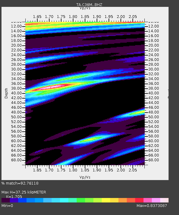
| Estimated Moho Depth: |
37.25 km |
| Estimated Crust Vp/Vs: |
1.71 |
| Assumed Crust Vp: |
6.459 km/s |
| Estimated Crust Vs: |
3.789 km/s |
| Estimated Crust Poisson's Ratio: |
0.24 |
|
| Radial Match: |
92.76118 % |
| Radial Bump: |
366 |
| Transverse Match: |
68.86899 % |
| Transverse Bump: |
400 |
| SOD ConfigId: |
21709731 |
| Insert Time: |
2020-07-20 18:30:55.304 +0000 |
| GWidth: |
2.5 |
| Max Bumps: |
400 |
| Tol: |
0.001 |
|

Signal To Noise
| Channel | StoN | STA | LTA |
| TA:C36M: :BHZ:20200706T18:28:00.724995Z | 5.624474 | 5.978731E-7 | 1.06298494E-7 |
| TA:C36M: :BHN:20200706T18:28:00.724995Z | 1.0539745 | 7.6813805E-8 | 7.2880134E-8 |
| TA:C36M: :BHE:20200706T18:28:00.724995Z | 1.5287265 | 1.1480042E-7 | 7.5095464E-8 |
| Arrivals |
| Ps | 4.2 SECOND |
| PpPs | 15 SECOND |
| PsPs/PpSs | 19 SECOND |


