You are here: Home > Network List > TA - USArray Transportable Network (new EarthScope stations) Stations List
> Station F19K Shaleruckik Mountain, AK, USA > Earthquake Result Viewer
F19K Shaleruckik Mountain, AK, USA - Earthquake Result Viewer
| Earthquake location: |
W. Caroline Islands, Micronesia |
| Earthquake latitude/longitude: |
12.1/140.2 |
| Earthquake time(UTC): |
2020/07/06 (188) 18:16:18 GMT |
| Earthquake Depth: |
12 km |
| Earthquake Magnitude: |
6.2 mww |
| Earthquake Catalog/Contributor: |
NEIC PDE/us |
|
| Network: |
TA USArray Transportable Network (new EarthScope stations) |
| Station: |
F19K Shaleruckik Mountain, AK, USA |
| Lat/Lon: |
66.83 N/157.77 W |
| Elevation: |
161 m |
|
| Distance: |
68.1 deg |
| Az: |
22.107 deg |
| Baz: |
248.514 deg |
| Ray Param: |
0.05649666 |
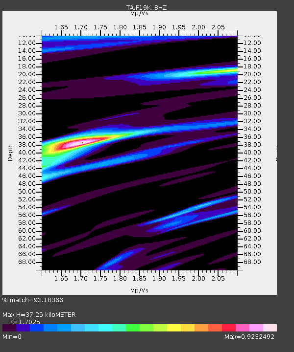
| Estimated Moho Depth: |
37.25 km |
| Estimated Crust Vp/Vs: |
1.70 |
| Assumed Crust Vp: |
6.577 km/s |
| Estimated Crust Vs: |
3.863 km/s |
| Estimated Crust Poisson's Ratio: |
0.24 |
|
| Radial Match: |
93.18366 % |
| Radial Bump: |
400 |
| Transverse Match: |
73.94587 % |
| Transverse Bump: |
400 |
| SOD ConfigId: |
21709731 |
| Insert Time: |
2020-07-20 18:31:30.503 +0000 |
| GWidth: |
2.5 |
| Max Bumps: |
400 |
| Tol: |
0.001 |
|

Signal To Noise
| Channel | StoN | STA | LTA |
| TA:F19K: :BHZ:20200706T18:26:47.274982Z | 9.710405 | 6.701143E-7 | 6.9009914E-8 |
| TA:F19K: :BHN:20200706T18:26:47.274982Z | 2.3520777 | 1.0955546E-7 | 4.657816E-8 |
| TA:F19K: :BHE:20200706T18:26:47.274982Z | 6.8420577 | 3.2795577E-7 | 4.7932332E-8 |
| Arrivals |
| Ps | 4.2 SECOND |
| PpPs | 15 SECOND |
| PsPs/PpSs | 19 SECOND |


