You are here: Home > Network List > TA - USArray Transportable Network (new EarthScope stations) Stations List
> Station F30M Barrier River, YT, CAN > Earthquake Result Viewer
F30M Barrier River, YT, CAN - Earthquake Result Viewer
| Earthquake location: |
W. Caroline Islands, Micronesia |
| Earthquake latitude/longitude: |
12.1/140.2 |
| Earthquake time(UTC): |
2020/07/06 (188) 18:16:18 GMT |
| Earthquake Depth: |
12 km |
| Earthquake Magnitude: |
6.2 mww |
| Earthquake Catalog/Contributor: |
NEIC PDE/us |
|
| Network: |
TA USArray Transportable Network (new EarthScope stations) |
| Station: |
F30M Barrier River, YT, CAN |
| Lat/Lon: |
67.61 N/135.79 W |
| Elevation: |
414 m |
|
| Distance: |
76.6 deg |
| Az: |
23.052 deg |
| Baz: |
269.089 deg |
| Ray Param: |
0.050859373 |
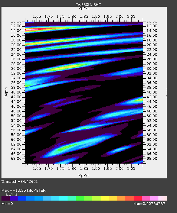
| Estimated Moho Depth: |
13.25 km |
| Estimated Crust Vp/Vs: |
1.60 |
| Assumed Crust Vp: |
6.171 km/s |
| Estimated Crust Vs: |
3.857 km/s |
| Estimated Crust Poisson's Ratio: |
0.18 |
|
| Radial Match: |
84.42661 % |
| Radial Bump: |
400 |
| Transverse Match: |
72.55362 % |
| Transverse Bump: |
400 |
| SOD ConfigId: |
21709731 |
| Insert Time: |
2020-07-20 18:31:41.709 +0000 |
| GWidth: |
2.5 |
| Max Bumps: |
400 |
| Tol: |
0.001 |
|
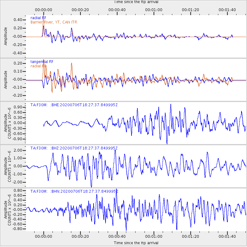
Signal To Noise
| Channel | StoN | STA | LTA |
| TA:F30M: :BHZ:20200706T18:27:37.849995Z | 8.16661 | 7.0507014E-7 | 8.6335724E-8 |
| TA:F30M: :BHN:20200706T18:27:37.849995Z | 0.6529357 | 5.635748E-8 | 8.631398E-8 |
| TA:F30M: :BHE:20200706T18:27:37.849995Z | 2.4521809 | 1.9894054E-7 | 8.112801E-8 |
| Arrivals |
| Ps | 1.3 SECOND |
| PpPs | 5.4 SECOND |
| PsPs/PpSs | 6.7 SECOND |


