You are here: Home > Network List > TA - USArray Transportable Network (new EarthScope stations) Stations List
> Station G15K Niukluk, AK, USA > Earthquake Result Viewer
G15K Niukluk, AK, USA - Earthquake Result Viewer
| Earthquake location: |
W. Caroline Islands, Micronesia |
| Earthquake latitude/longitude: |
12.1/140.2 |
| Earthquake time(UTC): |
2020/07/06 (188) 18:16:18 GMT |
| Earthquake Depth: |
12 km |
| Earthquake Magnitude: |
6.2 mww |
| Earthquake Catalog/Contributor: |
NEIC PDE/us |
|
| Network: |
TA USArray Transportable Network (new EarthScope stations) |
| Station: |
G15K Niukluk, AK, USA |
| Lat/Lon: |
64.99 N/164.04 W |
| Elevation: |
249 m |
|
| Distance: |
65.0 deg |
| Az: |
22.792 deg |
| Baz: |
243.07 deg |
| Ray Param: |
0.058534842 |
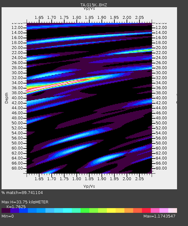
| Estimated Moho Depth: |
33.75 km |
| Estimated Crust Vp/Vs: |
1.76 |
| Assumed Crust Vp: |
6.276 km/s |
| Estimated Crust Vs: |
3.561 km/s |
| Estimated Crust Poisson's Ratio: |
0.26 |
|
| Radial Match: |
89.741104 % |
| Radial Bump: |
400 |
| Transverse Match: |
72.11638 % |
| Transverse Bump: |
400 |
| SOD ConfigId: |
21709731 |
| Insert Time: |
2020-07-20 18:31:44.702 +0000 |
| GWidth: |
2.5 |
| Max Bumps: |
400 |
| Tol: |
0.001 |
|

Signal To Noise
| Channel | StoN | STA | LTA |
| TA:G15K: :BHZ:20200706T18:26:27.500019Z | 7.4305716 | 6.3908675E-7 | 8.600776E-8 |
| TA:G15K: :BHN:20200706T18:26:27.500019Z | 1.6260084 | 9.691014E-8 | 5.9600023E-8 |
| TA:G15K: :BHE:20200706T18:26:27.500019Z | 4.196989 | 2.5991207E-7 | 6.1928226E-8 |
| Arrivals |
| Ps | 4.3 SECOND |
| PpPs | 14 SECOND |
| PsPs/PpSs | 19 SECOND |


