You are here: Home > Network List > TA - USArray Transportable Network (new EarthScope stations) Stations List
> Station G29M Pine Creek, YT, CAN > Earthquake Result Viewer
G29M Pine Creek, YT, CAN - Earthquake Result Viewer
| Earthquake location: |
W. Caroline Islands, Micronesia |
| Earthquake latitude/longitude: |
12.1/140.2 |
| Earthquake time(UTC): |
2020/07/06 (188) 18:16:18 GMT |
| Earthquake Depth: |
12 km |
| Earthquake Magnitude: |
6.2 mww |
| Earthquake Catalog/Contributor: |
NEIC PDE/us |
|
| Network: |
TA USArray Transportable Network (new EarthScope stations) |
| Station: |
G29M Pine Creek, YT, CAN |
| Lat/Lon: |
66.91 N/138.02 W |
| Elevation: |
572 m |
|
| Distance: |
75.8 deg |
| Az: |
23.745 deg |
| Baz: |
267.195 deg |
| Ray Param: |
0.05146032 |
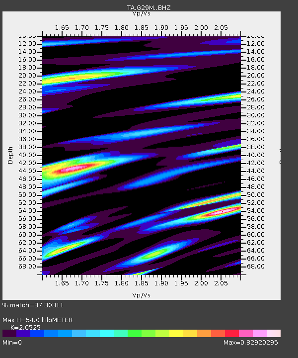
| Estimated Moho Depth: |
54.0 km |
| Estimated Crust Vp/Vs: |
2.05 |
| Assumed Crust Vp: |
6.577 km/s |
| Estimated Crust Vs: |
3.204 km/s |
| Estimated Crust Poisson's Ratio: |
0.34 |
|
| Radial Match: |
87.30311 % |
| Radial Bump: |
400 |
| Transverse Match: |
84.5309 % |
| Transverse Bump: |
400 |
| SOD ConfigId: |
21709731 |
| Insert Time: |
2020-07-20 18:31:59.073 +0000 |
| GWidth: |
2.5 |
| Max Bumps: |
400 |
| Tol: |
0.001 |
|

Signal To Noise
| Channel | StoN | STA | LTA |
| TA:G29M: :BHZ:20200706T18:27:32.800007Z | 7.4917603 | 8.335058E-7 | 1.11256334E-7 |
| TA:G29M: :BHN:20200706T18:27:32.800007Z | 1.421987 | 9.398682E-8 | 6.609541E-8 |
| TA:G29M: :BHE:20200706T18:27:32.800007Z | 2.000631 | 2.4602156E-7 | 1.2297197E-7 |
| Arrivals |
| Ps | 8.9 SECOND |
| PpPs | 24 SECOND |
| PsPs/PpSs | 33 SECOND |


