You are here: Home > Network List > TA - USArray Transportable Network (new EarthScope stations) Stations List
> Station J30M Hart River, Yukon, CAN > Earthquake Result Viewer
J30M Hart River, Yukon, CAN - Earthquake Result Viewer
| Earthquake location: |
W. Caroline Islands, Micronesia |
| Earthquake latitude/longitude: |
12.1/140.2 |
| Earthquake time(UTC): |
2020/07/06 (188) 18:16:18 GMT |
| Earthquake Depth: |
12 km |
| Earthquake Magnitude: |
6.2 mww |
| Earthquake Catalog/Contributor: |
NEIC PDE/us |
|
| Network: |
TA USArray Transportable Network (new EarthScope stations) |
| Station: |
J30M Hart River, Yukon, CAN |
| Lat/Lon: |
64.58 N/136.33 W |
| Elevation: |
1419 m |
|
| Distance: |
76.4 deg |
| Az: |
26.184 deg |
| Baz: |
269.323 deg |
| Ray Param: |
0.051038146 |
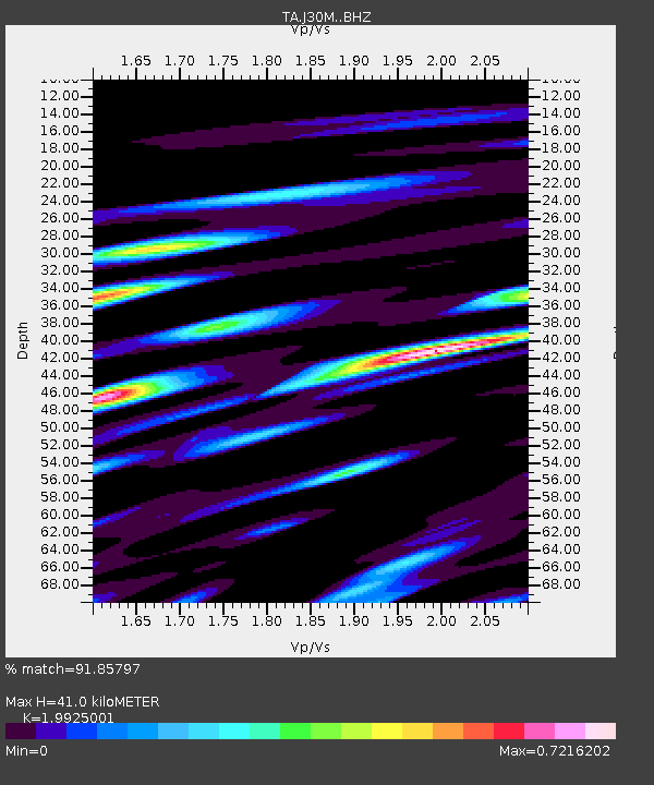
| Estimated Moho Depth: |
41.0 km |
| Estimated Crust Vp/Vs: |
1.99 |
| Assumed Crust Vp: |
6.566 km/s |
| Estimated Crust Vs: |
3.295 km/s |
| Estimated Crust Poisson's Ratio: |
0.33 |
|
| Radial Match: |
91.85797 % |
| Radial Bump: |
400 |
| Transverse Match: |
83.28963 % |
| Transverse Bump: |
400 |
| SOD ConfigId: |
21709731 |
| Insert Time: |
2020-07-20 18:32:24.362 +0000 |
| GWidth: |
2.5 |
| Max Bumps: |
400 |
| Tol: |
0.001 |
|

Signal To Noise
| Channel | StoN | STA | LTA |
| TA:J30M: :BHZ:20200706T18:27:36.375019Z | 9.259379 | 4.2695547E-7 | 4.6110593E-8 |
| TA:J30M: :BHN:20200706T18:27:36.375019Z | 1.7471405 | 7.527079E-8 | 4.3082277E-8 |
| TA:J30M: :BHE:20200706T18:27:36.375019Z | 3.7605178 | 1.7968853E-7 | 4.7782923E-8 |
| Arrivals |
| Ps | 6.4 SECOND |
| PpPs | 18 SECOND |
| PsPs/PpSs | 25 SECOND |


