You are here: Home > Network List > TA - USArray Transportable Network (new EarthScope stations) Stations List
> Station M11K Mekoryuk, AK, USA > Earthquake Result Viewer
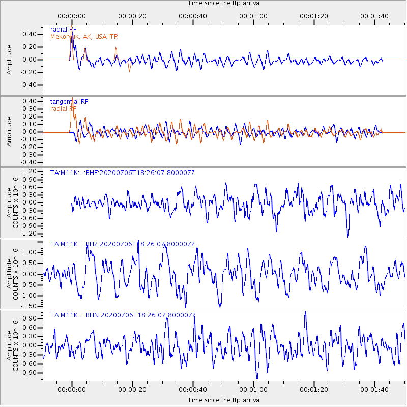
M11K Mekoryuk, AK, USA - Earthquake Result Viewer
*The percent match for this event was below the threshold and hence no stack was calculated.
| Earthquake location: |
W. Caroline Islands, Micronesia |
| Earthquake latitude/longitude: |
12.1/140.2 |
| Earthquake time(UTC): |
2020/07/06 (188) 18:16:18 GMT |
| Earthquake Depth: |
12 km |
| Earthquake Magnitude: |
6.2 mww |
| Earthquake Catalog/Contributor: |
NEIC PDE/us |
|
| Network: |
TA USArray Transportable Network (new EarthScope stations) |
| Station: |
M11K Mekoryuk, AK, USA |
| Lat/Lon: |
60.38 N/166.20 W |
| Elevation: |
3.0 m |
|
| Distance: |
62.0 deg |
| Az: |
26.891 deg |
| Baz: |
242.978 deg |
| Ray Param: |
$rayparam |
*The percent match for this event was below the threshold and hence was not used in the summary stack. |
|
| Radial Match: |
79.236496 % |
| Radial Bump: |
400 |
| Transverse Match: |
70.38212 % |
| Transverse Bump: |
400 |
| SOD ConfigId: |
21709731 |
| Insert Time: |
2020-07-20 18:32:36.059 +0000 |
| GWidth: |
2.5 |
| Max Bumps: |
400 |
| Tol: |
0.001 |
|
Signal To Noise
| Channel | StoN | STA | LTA |
| TA:M11K: :BHZ:20200706T18:26:07.800007Z | 3.0725007 | 6.188848E-7 | 2.0142707E-7 |
| TA:M11K: :BHN:20200706T18:26:07.800007Z | 1.3252708 | 2.2808969E-7 | 1.7210799E-7 |
| TA:M11K: :BHE:20200706T18:26:07.800007Z | 1.5331973 | 2.664982E-7 | 1.738186E-7 |
| Arrivals |
| Ps | |
| PpPs | |
| PsPs/PpSs | |


