You are here: Home > Network List > TD - TransAlta Monitoring Network Stations List
> Station TD004 Z > Earthquake Result Viewer
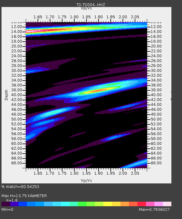
TD004 Z - Earthquake Result Viewer
| Earthquake location: |
W. Caroline Islands, Micronesia |
| Earthquake latitude/longitude: |
12.1/140.2 |
| Earthquake time(UTC): |
2020/07/06 (188) 18:16:18 GMT |
| Earthquake Depth: |
12 km |
| Earthquake Magnitude: |
6.2 mww |
| Earthquake Catalog/Contributor: |
NEIC PDE/us |
|
| Network: |
TD TransAlta Monitoring Network |
| Station: |
TD004 Z |
| Lat/Lon: |
53.47 N/114.63 W |
| Elevation: |
791 m |
|
| Distance: |
89.2 deg |
| Az: |
35.252 deg |
| Baz: |
289.192 deg |
| Ray Param: |
0.042013906 |
| Estimated Moho Depth: |
13.75 km |
| Estimated Crust Vp/Vs: |
1.60 |
| Assumed Crust Vp: |
6.426 km/s |
| Estimated Crust Vs: |
4.016 km/s |
| Estimated Crust Poisson's Ratio: |
0.18 |
|
| Radial Match: |
80.54253 % |
| Radial Bump: |
331 |
| Transverse Match: |
80.91537 % |
| Transverse Bump: |
400 |
| SOD ConfigId: |
21709731 |
| Insert Time: |
2020-07-20 18:33:26.250 +0000 |
| GWidth: |
2.5 |
| Max Bumps: |
400 |
| Tol: |
0.001 |
|

Signal To Noise
| Channel | StoN | STA | LTA |
| TD:TD004: :HHZ:20200706T18:28:42.71999Z | 3.7449744 | 2.70975E-7 | 7.235697E-8 |
| TD:TD004: :HH1:20200706T18:28:42.71999Z | 2.0825214 | 1.866598E-7 | 8.963164E-8 |
| TD:TD004: :HH2:20200706T18:28:42.71999Z | 1.2814033 | 1.5362717E-7 | 1.1988978E-7 |
| Arrivals |
| Ps | 1.3 SECOND |
| PpPs | 5.4 SECOND |
| PsPs/PpSs | 6.7 SECOND |


