You are here: Home > Network List > TD - TransAlta Monitoring Network Stations List
> Station TD007 Z > Earthquake Result Viewer
TD007 Z - Earthquake Result Viewer
| Earthquake location: |
W. Caroline Islands, Micronesia |
| Earthquake latitude/longitude: |
12.1/140.2 |
| Earthquake time(UTC): |
2020/07/06 (188) 18:16:18 GMT |
| Earthquake Depth: |
12 km |
| Earthquake Magnitude: |
6.2 mww |
| Earthquake Catalog/Contributor: |
NEIC PDE/us |
|
| Network: |
TD TransAlta Monitoring Network |
| Station: |
TD007 Z |
| Lat/Lon: |
52.91 N/115.62 W |
| Elevation: |
988 m |
|
| Distance: |
88.8 deg |
| Az: |
35.977 deg |
| Baz: |
288.414 deg |
| Ray Param: |
0.042287678 |
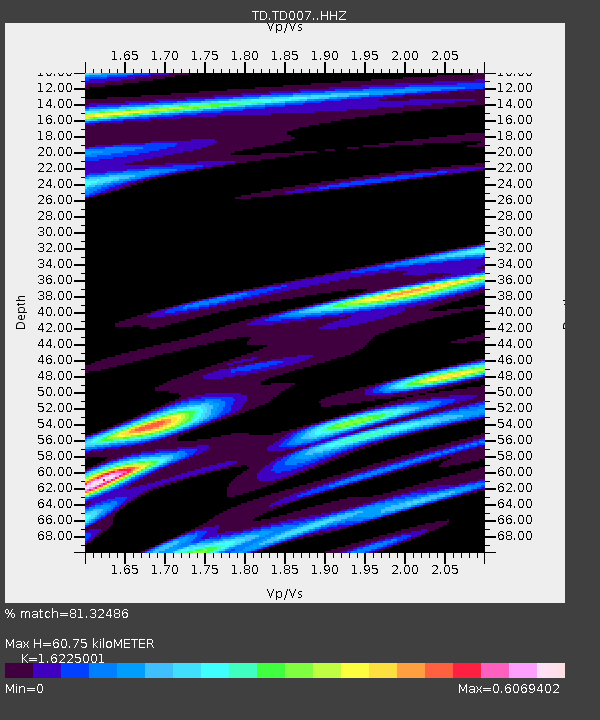
| Estimated Moho Depth: |
60.75 km |
| Estimated Crust Vp/Vs: |
1.62 |
| Assumed Crust Vp: |
6.426 km/s |
| Estimated Crust Vs: |
3.961 km/s |
| Estimated Crust Poisson's Ratio: |
0.19 |
|
| Radial Match: |
81.32486 % |
| Radial Bump: |
400 |
| Transverse Match: |
74.6852 % |
| Transverse Bump: |
400 |
| SOD ConfigId: |
21709731 |
| Insert Time: |
2020-07-20 18:33:28.632 +0000 |
| GWidth: |
2.5 |
| Max Bumps: |
400 |
| Tol: |
0.001 |
|

Signal To Noise
| Channel | StoN | STA | LTA |
| TD:TD007: :HHZ:20200706T18:28:40.930012Z | 2.579916 | 2.6583058E-7 | 1.0303846E-7 |
| TD:TD007: :HH1:20200706T18:28:40.930012Z | 1.9592047 | 1.4054771E-7 | 7.173713E-8 |
| TD:TD007: :HH2:20200706T18:28:40.930012Z | 0.7064359 | 7.6045154E-8 | 1.07646215E-7 |
| Arrivals |
| Ps | 6.0 SECOND |
| PpPs | 24 SECOND |
| PsPs/PpSs | 30 SECOND |


