You are here: Home > Network List > TJ - Tajikistan National Seismic Network Stations List
> Station SHAA Shaartuz, Tajikistan > Earthquake Result Viewer
SHAA Shaartuz, Tajikistan - Earthquake Result Viewer
| Earthquake location: |
W. Caroline Islands, Micronesia |
| Earthquake latitude/longitude: |
12.1/140.2 |
| Earthquake time(UTC): |
2020/07/06 (188) 18:16:18 GMT |
| Earthquake Depth: |
12 km |
| Earthquake Magnitude: |
6.2 mww |
| Earthquake Catalog/Contributor: |
NEIC PDE/us |
|
| Network: |
TJ Tajikistan National Seismic Network |
| Station: |
SHAA Shaartuz, Tajikistan |
| Lat/Lon: |
37.56 N/68.12 E |
| Elevation: |
868 m |
|
| Distance: |
68.6 deg |
| Az: |
305.688 deg |
| Baz: |
91.072 deg |
| Ray Param: |
0.056187067 |
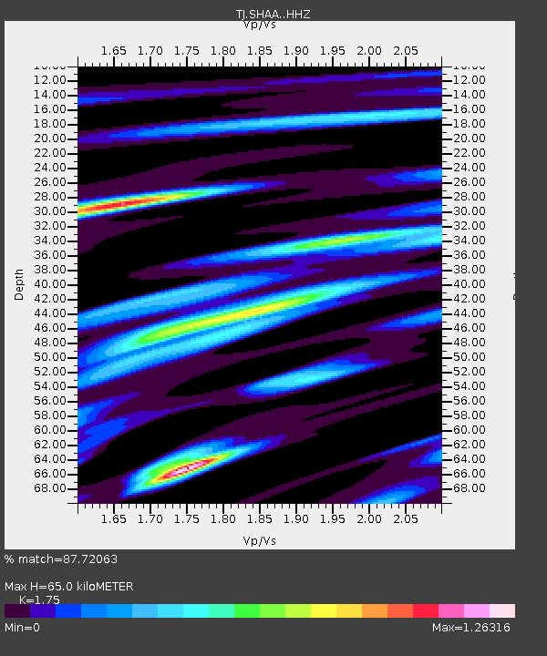
| Estimated Moho Depth: |
65.0 km |
| Estimated Crust Vp/Vs: |
1.75 |
| Assumed Crust Vp: |
6.213 km/s |
| Estimated Crust Vs: |
3.551 km/s |
| Estimated Crust Poisson's Ratio: |
0.26 |
|
| Radial Match: |
87.72063 % |
| Radial Bump: |
400 |
| Transverse Match: |
90.57064 % |
| Transverse Bump: |
306 |
| SOD ConfigId: |
21709731 |
| Insert Time: |
2020-07-20 18:33:45.355 +0000 |
| GWidth: |
2.5 |
| Max Bumps: |
400 |
| Tol: |
0.001 |
|
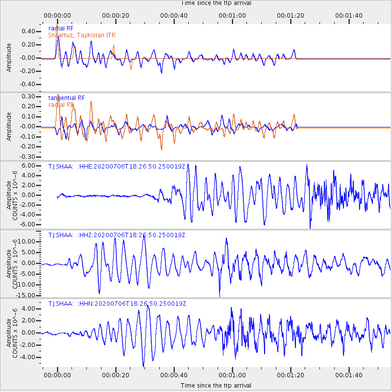
Signal To Noise
| Channel | StoN | STA | LTA |
| TJ:SHAA: :HHZ:20200706T18:26:50.250019Z | 5.10916 | 8.327588E-7 | 1.6299329E-7 |
| TJ:SHAA: :HHN:20200706T18:26:50.250019Z | 0.9110604 | 1.5579081E-7 | 1.7099944E-7 |
| TJ:SHAA: :HHE:20200706T18:26:50.250019Z | 3.0999207 | 4.1512095E-7 | 1.339134E-7 |
| Arrivals |
| Ps | 8.1 SECOND |
| PpPs | 28 SECOND |
| PsPs/PpSs | 36 SECOND |


