You are here: Home > Network List > UO - University of Oregon Regional Network Stations List
> Station PINE Pine Mountain Observatory, OR > Earthquake Result Viewer
PINE Pine Mountain Observatory, OR - Earthquake Result Viewer
| Earthquake location: |
W. Caroline Islands, Micronesia |
| Earthquake latitude/longitude: |
12.1/140.2 |
| Earthquake time(UTC): |
2020/07/06 (188) 18:16:18 GMT |
| Earthquake Depth: |
12 km |
| Earthquake Magnitude: |
6.2 mww |
| Earthquake Catalog/Contributor: |
NEIC PDE/us |
|
| Network: |
UO University of Oregon Regional Network |
| Station: |
PINE Pine Mountain Observatory, OR |
| Lat/Lon: |
43.79 N/120.94 W |
| Elevation: |
1916 m |
|
| Distance: |
88.0 deg |
| Az: |
45.729 deg |
| Baz: |
284.701 deg |
| Ray Param: |
0.042895213 |
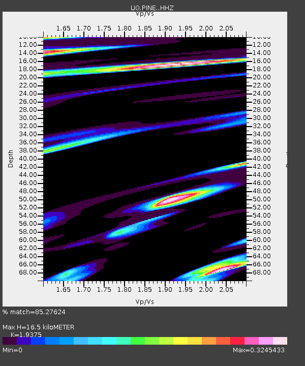
| Estimated Moho Depth: |
16.5 km |
| Estimated Crust Vp/Vs: |
1.94 |
| Assumed Crust Vp: |
6.597 km/s |
| Estimated Crust Vs: |
3.405 km/s |
| Estimated Crust Poisson's Ratio: |
0.32 |
|
| Radial Match: |
85.27624 % |
| Radial Bump: |
400 |
| Transverse Match: |
68.1464 % |
| Transverse Bump: |
400 |
| SOD ConfigId: |
21709731 |
| Insert Time: |
2020-07-20 18:34:15.087 +0000 |
| GWidth: |
2.5 |
| Max Bumps: |
400 |
| Tol: |
0.001 |
|

Signal To Noise
| Channel | StoN | STA | LTA |
| UO:PINE: :HHZ:20200706T18:28:37.089985Z | 2.806291 | 1.820324E-7 | 6.486582E-8 |
| UO:PINE: :HHN:20200706T18:28:37.089985Z | 0.8177685 | 1.0231455E-7 | 1.2511431E-7 |
| UO:PINE: :HHE:20200706T18:28:37.089985Z | 1.0964986 | 1.1137307E-7 | 1.0157156E-7 |
| Arrivals |
| Ps | 2.4 SECOND |
| PpPs | 7.2 SECOND |
| PsPs/PpSs | 9.6 SECOND |


