You are here: Home > Network List > UW - Pacific Northwest Regional Seismic Network Stations List
> Station UMAT Pilot Rock, OR, USA > Earthquake Result Viewer
UMAT Pilot Rock, OR, USA - Earthquake Result Viewer

| Earthquake location: |
W. Caroline Islands, Micronesia |
| Earthquake latitude/longitude: |
12.1/140.2 |
| Earthquake time(UTC): |
2020/07/06 (188) 18:16:18 GMT |
| Earthquake Depth: |
12 km |
| Earthquake Magnitude: |
6.2 mww |
| Earthquake Catalog/Contributor: |
NEIC PDE/us |
|
| Network: |
UW Pacific Northwest Regional Seismic Network |
| Station: |
UMAT Pilot Rock, OR, USA |
| Lat/Lon: |
45.29 N/118.96 W |
| Elevation: |
1318 m |
|
| Distance: |
89.0 deg |
| Az: |
43.909 deg |
| Baz: |
286.039 deg |
| Ray Param: |
0.042178445 |
| Estimated Moho Depth: |
34.5 km |
| Estimated Crust Vp/Vs: |
1.91 |
| Assumed Crust Vp: |
6.571 km/s |
| Estimated Crust Vs: |
3.445 km/s |
| Estimated Crust Poisson's Ratio: |
0.31 |
|
| Radial Match: |
93.24847 % |
| Radial Bump: |
299 |
| Transverse Match: |
80.33798 % |
| Transverse Bump: |
395 |
| SOD ConfigId: |
21709731 |
| Insert Time: |
2020-07-20 18:35:50.525 +0000 |
| GWidth: |
2.5 |
| Max Bumps: |
400 |
| Tol: |
0.001 |
|
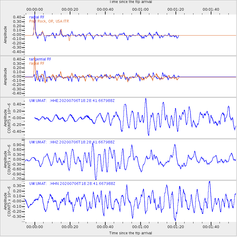
Signal To Noise
| Channel | StoN | STA | LTA |
| UW:UMAT: :HHZ:20200706T18:28:41.667988Z | 1.7456459 | 1.939962E-7 | 1.1113147E-7 |
| UW:UMAT: :HHN:20200706T18:28:41.667988Z | 1.0380812 | 7.2811744E-8 | 7.014071E-8 |
| UW:UMAT: :HHE:20200706T18:28:41.667988Z | 1.4990118 | 7.960748E-8 | 5.310664E-8 |
| Arrivals |
| Ps | 4.9 SECOND |
| PpPs | 15 SECOND |
| PsPs/PpSs | 20 SECOND |


