You are here: Home > Network List > UW - Pacific Northwest Regional Seismic Network Stations List
> Station PASS Maple Falls, WA, USA > Earthquake Result Viewer
PASS Maple Falls, WA, USA - Earthquake Result Viewer

| Earthquake location: |
W. Caroline Islands, Micronesia |
| Earthquake latitude/longitude: |
12.1/140.2 |
| Earthquake time(UTC): |
2020/07/06 (188) 18:16:18 GMT |
| Earthquake Depth: |
12 km |
| Earthquake Magnitude: |
6.2 mww |
| Earthquake Catalog/Contributor: |
NEIC PDE/us |
|
| Network: |
UW Pacific Northwest Regional Seismic Network |
| Station: |
PASS Maple Falls, WA, USA |
| Lat/Lon: |
49.00 N/122.09 W |
| Elevation: |
174 m |
|
| Distance: |
86.0 deg |
| Az: |
40.867 deg |
| Baz: |
283.619 deg |
| Ray Param: |
0.044380285 |
| Estimated Moho Depth: |
64.5 km |
| Estimated Crust Vp/Vs: |
1.75 |
| Assumed Crust Vp: |
6.566 km/s |
| Estimated Crust Vs: |
3.757 km/s |
| Estimated Crust Poisson's Ratio: |
0.26 |
|
| Radial Match: |
82.844086 % |
| Radial Bump: |
400 |
| Transverse Match: |
70.58345 % |
| Transverse Bump: |
400 |
| SOD ConfigId: |
21709731 |
| Insert Time: |
2020-07-20 18:35:56.000 +0000 |
| GWidth: |
2.5 |
| Max Bumps: |
400 |
| Tol: |
0.001 |
|
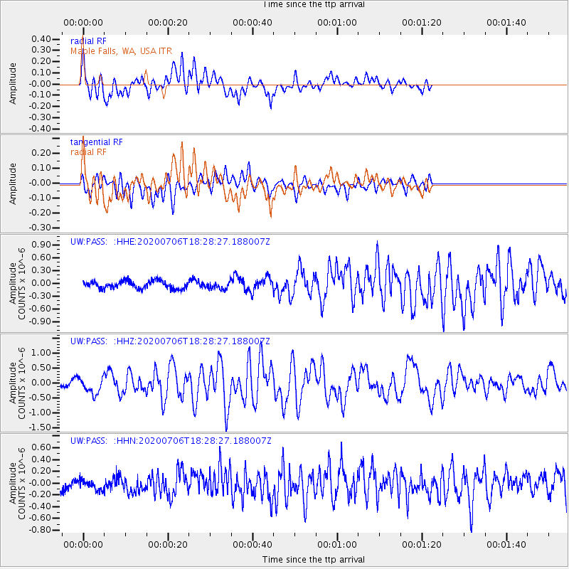
Signal To Noise
| Channel | StoN | STA | LTA |
| UW:PASS: :HHZ:20200706T18:28:27.188007Z | 2.3273425 | 2.658691E-7 | 1.142372E-7 |
| UW:PASS: :HHN:20200706T18:28:27.188007Z | 0.9159547 | 8.789633E-8 | 9.596144E-8 |
| UW:PASS: :HHE:20200706T18:28:27.188007Z | 0.99493766 | 8.8174E-8 | 8.8622635E-8 |
| Arrivals |
| Ps | 7.5 SECOND |
| PpPs | 26 SECOND |
| PsPs/PpSs | 34 SECOND |


