You are here: Home > Network List > AK - Alaska Regional Network Stations List
> Station HIN Hinchinbrook, AK, USA > Earthquake Result Viewer
HIN Hinchinbrook, AK, USA - Earthquake Result Viewer
| Earthquake location: |
Southeast Of Honshu, Japan |
| Earthquake latitude/longitude: |
31.5/138.2 |
| Earthquake time(UTC): |
2020/07/06 (188) 18:19:09 GMT |
| Earthquake Depth: |
381 km |
| Earthquake Magnitude: |
5.6 Mww |
| Earthquake Catalog/Contributor: |
NEIC PDE/us |
|
| Network: |
AK Alaska Regional Network |
| Station: |
HIN Hinchinbrook, AK, USA |
| Lat/Lon: |
60.40 N/146.50 W |
| Elevation: |
623 m |
|
| Distance: |
56.1 deg |
| Az: |
35.382 deg |
| Baz: |
274.865 deg |
| Ray Param: |
0.0629671 |
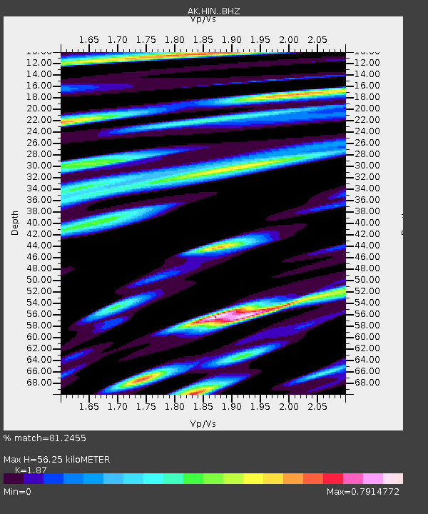
| Estimated Moho Depth: |
56.25 km |
| Estimated Crust Vp/Vs: |
1.87 |
| Assumed Crust Vp: |
6.566 km/s |
| Estimated Crust Vs: |
3.511 km/s |
| Estimated Crust Poisson's Ratio: |
0.30 |
|
| Radial Match: |
81.2455 % |
| Radial Bump: |
400 |
| Transverse Match: |
77.29296 % |
| Transverse Bump: |
400 |
| SOD ConfigId: |
21709731 |
| Insert Time: |
2020-07-20 18:38:03.293 +0000 |
| GWidth: |
2.5 |
| Max Bumps: |
400 |
| Tol: |
0.001 |
|

Signal To Noise
| Channel | StoN | STA | LTA |
| AK:HIN: :BHZ:20200706T18:27:39.187997Z | 1.5762246 | 9.1357225E-7 | 5.795953E-7 |
| AK:HIN: :BHN:20200706T18:27:39.187997Z | 2.5026224 | 5.4620233E-7 | 2.1825198E-7 |
| AK:HIN: :BHE:20200706T18:27:39.187997Z | 1.7386581 | 4.79872E-7 | 2.7600137E-7 |
| Arrivals |
| Ps | 7.8 SECOND |
| PpPs | 23 SECOND |
| PsPs/PpSs | 31 SECOND |


