You are here: Home > Network List > AK - Alaska Regional Network Stations List
> Station P16K Nushagak River, AK, USA > Earthquake Result Viewer
P16K Nushagak River, AK, USA - Earthquake Result Viewer
| Earthquake location: |
Southeast Of Honshu, Japan |
| Earthquake latitude/longitude: |
31.5/138.2 |
| Earthquake time(UTC): |
2020/07/06 (188) 18:19:09 GMT |
| Earthquake Depth: |
381 km |
| Earthquake Magnitude: |
5.6 Mww |
| Earthquake Catalog/Contributor: |
NEIC PDE/us |
|
| Network: |
AK Alaska Regional Network |
| Station: |
P16K Nushagak River, AK, USA |
| Lat/Lon: |
59.03 N/157.99 W |
| Elevation: |
86 m |
|
| Distance: |
50.3 deg |
| Az: |
37.14 deg |
| Baz: |
266.009 deg |
| Ray Param: |
0.06663498 |
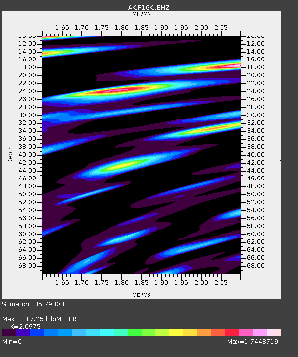
| Estimated Moho Depth: |
17.25 km |
| Estimated Crust Vp/Vs: |
2.10 |
| Assumed Crust Vp: |
6.276 km/s |
| Estimated Crust Vs: |
2.992 km/s |
| Estimated Crust Poisson's Ratio: |
0.35 |
|
| Radial Match: |
85.79303 % |
| Radial Bump: |
400 |
| Transverse Match: |
77.14455 % |
| Transverse Bump: |
381 |
| SOD ConfigId: |
21709731 |
| Insert Time: |
2020-07-20 18:38:54.414 +0000 |
| GWidth: |
2.5 |
| Max Bumps: |
400 |
| Tol: |
0.001 |
|

Signal To Noise
| Channel | StoN | STA | LTA |
| AK:P16K: :BHZ:20200706T18:26:57.500008Z | 1.3140743 | 1.268941E-6 | 9.65654E-7 |
| AK:P16K: :BHN:20200706T18:26:57.500008Z | 0.784156 | 6.7362464E-7 | 8.590441E-7 |
| AK:P16K: :BHE:20200706T18:26:57.500008Z | 2.0974703 | 1.1167409E-6 | 5.3242275E-7 |
| Arrivals |
| Ps | 3.2 SECOND |
| PpPs | 8.1 SECOND |
| PsPs/PpSs | 11 SECOND |


