You are here: Home > Network List > AK - Alaska Regional Network Stations List
> Station S31K Pelican, AK, USA > Earthquake Result Viewer
S31K Pelican, AK, USA - Earthquake Result Viewer
| Earthquake location: |
Southeast Of Honshu, Japan |
| Earthquake latitude/longitude: |
31.5/138.2 |
| Earthquake time(UTC): |
2020/07/06 (188) 18:19:09 GMT |
| Earthquake Depth: |
381 km |
| Earthquake Magnitude: |
5.6 Mww |
| Earthquake Catalog/Contributor: |
NEIC PDE/us |
|
| Network: |
AK Alaska Regional Network |
| Station: |
S31K Pelican, AK, USA |
| Lat/Lon: |
57.96 N/136.23 W |
| Elevation: |
34 m |
|
| Distance: |
61.7 deg |
| Az: |
37.14 deg |
| Baz: |
284.589 deg |
| Ray Param: |
0.059408616 |
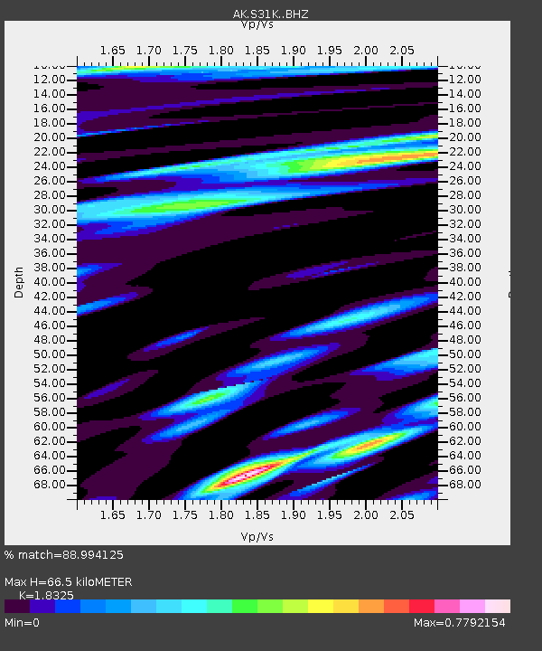
| Estimated Moho Depth: |
66.5 km |
| Estimated Crust Vp/Vs: |
1.83 |
| Assumed Crust Vp: |
6.134 km/s |
| Estimated Crust Vs: |
3.347 km/s |
| Estimated Crust Poisson's Ratio: |
0.29 |
|
| Radial Match: |
88.994125 % |
| Radial Bump: |
400 |
| Transverse Match: |
74.36015 % |
| Transverse Bump: |
400 |
| SOD ConfigId: |
21709731 |
| Insert Time: |
2020-07-20 18:39:15.215 +0000 |
| GWidth: |
2.5 |
| Max Bumps: |
400 |
| Tol: |
0.001 |
|

Signal To Noise
| Channel | StoN | STA | LTA |
| AK:S31K: :BHZ:20200706T18:28:17.299996Z | 1.117787 | 4.8811813E-7 | 4.366826E-7 |
| AK:S31K: :BHN:20200706T18:28:17.299996Z | 1.7573558 | 1.8926585E-7 | 1.07699215E-7 |
| AK:S31K: :BHE:20200706T18:28:17.299996Z | 1.4217807 | 3.120599E-7 | 2.1948524E-7 |
| Arrivals |
| Ps | 9.4 SECOND |
| PpPs | 30 SECOND |
| PsPs/PpSs | 39 SECOND |


