You are here: Home > Network List > AV - Alaska Volcano Observatory Stations List
> Station AMKA Regional Station, Amchitka Island, Alaska > Earthquake Result Viewer
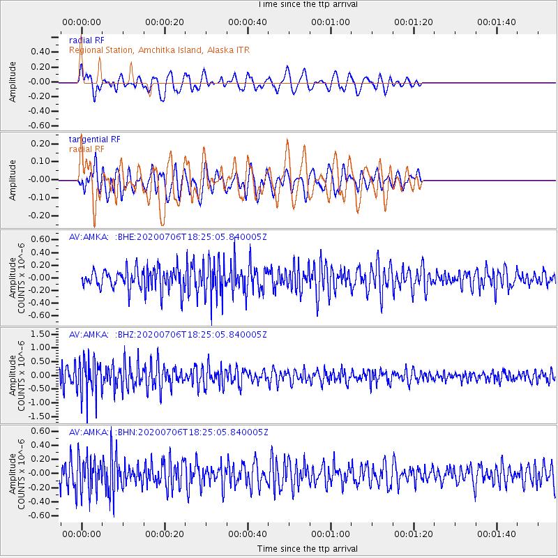
AMKA Regional Station, Amchitka Island, Alaska - Earthquake Result Viewer
*The percent match for this event was below the threshold and hence no stack was calculated.
| Earthquake location: |
Southeast Of Honshu, Japan |
| Earthquake latitude/longitude: |
31.5/138.2 |
| Earthquake time(UTC): |
2020/07/06 (188) 18:19:09 GMT |
| Earthquake Depth: |
381 km |
| Earthquake Magnitude: |
5.6 Mww |
| Earthquake Catalog/Contributor: |
NEIC PDE/us |
|
| Network: |
AV Alaska Volcano Observatory |
| Station: |
AMKA Regional Station, Amchitka Island, Alaska |
| Lat/Lon: |
51.38 N/179.30 E |
| Elevation: |
116 m |
|
| Distance: |
36.1 deg |
| Az: |
44.439 deg |
| Baz: |
252.649 deg |
| Ray Param: |
$rayparam |
*The percent match for this event was below the threshold and hence was not used in the summary stack. |
|
| Radial Match: |
70.353264 % |
| Radial Bump: |
400 |
| Transverse Match: |
51.7041 % |
| Transverse Bump: |
400 |
| SOD ConfigId: |
21709731 |
| Insert Time: |
2020-07-20 18:40:43.820 +0000 |
| GWidth: |
2.5 |
| Max Bumps: |
400 |
| Tol: |
0.001 |
|
Signal To Noise
| Channel | StoN | STA | LTA |
| AV:AMKA: :BHZ:20200706T18:25:05.840005Z | 1.6189443 | 6.558197E-7 | 4.0509096E-7 |
| AV:AMKA: :BHN:20200706T18:25:05.840005Z | 1.801708 | 2.3681146E-7 | 1.314372E-7 |
| AV:AMKA: :BHE:20200706T18:25:05.840005Z | 1.7796204 | 2.8535166E-7 | 1.6034411E-7 |
| Arrivals |
| Ps | |
| PpPs | |
| PsPs/PpSs | |


