You are here: Home > Network List > US - United States National Seismic Network Stations List
> Station AMTX Amarillo, Texas, USA > Earthquake Result Viewer
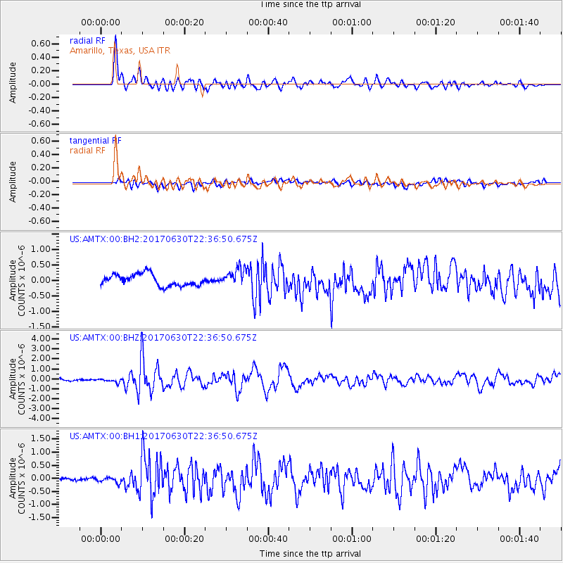
AMTX Amarillo, Texas, USA - Earthquake Result Viewer
*The percent match for this event was below the threshold and hence no stack was calculated.
| Earthquake location: |
Near Coast Of Ecuador |
| Earthquake latitude/longitude: |
-0.3/-80.5 |
| Earthquake time(UTC): |
2017/06/30 (181) 22:29:44 GMT |
| Earthquake Depth: |
7.4 km |
| Earthquake Magnitude: |
6.0 Mww |
| Earthquake Catalog/Contributor: |
NEIC PDE/us |
|
| Network: |
US United States National Seismic Network |
| Station: |
AMTX Amarillo, Texas, USA |
| Lat/Lon: |
34.53 N/101.41 W |
| Elevation: |
1010 m |
|
| Distance: |
39.8 deg |
| Az: |
332.619 deg |
| Baz: |
146.148 deg |
| Ray Param: |
$rayparam |
*The percent match for this event was below the threshold and hence was not used in the summary stack. |
|
| Radial Match: |
82.8591 % |
| Radial Bump: |
400 |
| Transverse Match: |
47.337265 % |
| Transverse Bump: |
400 |
| SOD ConfigId: |
2140511 |
| Insert Time: |
2017-07-14 14:25:53.630 +0000 |
| GWidth: |
2.5 |
| Max Bumps: |
400 |
| Tol: |
0.001 |
|
Signal To Noise
| Channel | StoN | STA | LTA |
| US:AMTX:00:BHZ:20170630T22:36:50.675Z | 2.1551113 | 1.9002783E-7 | 8.817542E-8 |
| US:AMTX:00:BH1:20170630T22:36:50.675Z | 1.0718156 | 9.802768E-8 | 9.1459455E-8 |
| US:AMTX:00:BH2:20170630T22:36:50.675Z | 0.48910388 | 9.391308E-8 | 1.920105E-7 |
| Arrivals |
| Ps | |
| PpPs | |
| PsPs/PpSs | |


