You are here: Home > Network List > AV - Alaska Volcano Observatory Stations List
> Station GSIG Igitkin Island, Great Sitkin Volcano, Alaska > Earthquake Result Viewer
GSIG Igitkin Island, Great Sitkin Volcano, Alaska - Earthquake Result Viewer

| Earthquake location: |
Southeast Of Honshu, Japan |
| Earthquake latitude/longitude: |
31.5/138.2 |
| Earthquake time(UTC): |
2020/07/06 (188) 18:19:09 GMT |
| Earthquake Depth: |
381 km |
| Earthquake Magnitude: |
5.6 Mww |
| Earthquake Catalog/Contributor: |
NEIC PDE/us |
|
| Network: |
AV Alaska Volcano Observatory |
| Station: |
GSIG Igitkin Island, Great Sitkin Volcano, Alaska |
| Lat/Lon: |
51.99 N/175.93 W |
| Elevation: |
407 m |
|
| Distance: |
39.1 deg |
| Az: |
44.768 deg |
| Baz: |
256.644 deg |
| Ray Param: |
0.073505506 |
| Estimated Moho Depth: |
19.5 km |
| Estimated Crust Vp/Vs: |
1.82 |
| Assumed Crust Vp: |
3.943 km/s |
| Estimated Crust Vs: |
2.173 km/s |
| Estimated Crust Poisson's Ratio: |
0.28 |
|
| Radial Match: |
82.34558 % |
| Radial Bump: |
400 |
| Transverse Match: |
64.4494 % |
| Transverse Bump: |
400 |
| SOD ConfigId: |
21709731 |
| Insert Time: |
2020-07-20 18:41:10.183 +0000 |
| GWidth: |
2.5 |
| Max Bumps: |
400 |
| Tol: |
0.001 |
|
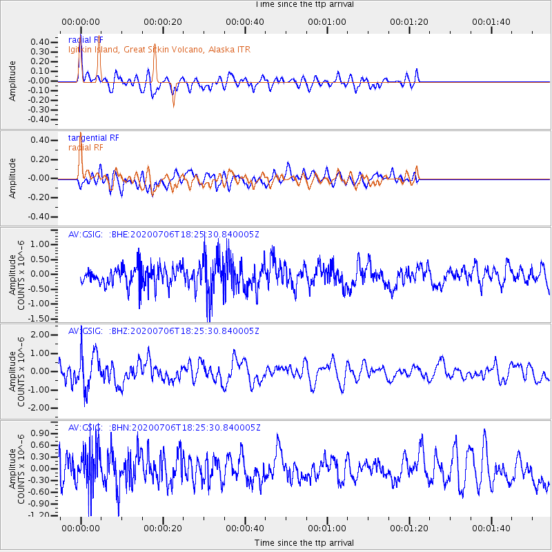
Signal To Noise
| Channel | StoN | STA | LTA |
| AV:GSIG: :BHZ:20200706T18:25:30.840005Z | 1.7593423 | 9.860232E-7 | 5.604499E-7 |
| AV:GSIG: :BHN:20200706T18:25:30.840005Z | 2.235828 | 5.4246453E-7 | 2.4262354E-7 |
| AV:GSIG: :BHE:20200706T18:25:30.840005Z | 2.2764816 | 6.722891E-7 | 2.9531935E-7 |
| Arrivals |
| Ps | 4.1 SECOND |
| PpPs | 14 SECOND |
| PsPs/PpSs | 18 SECOND |


