You are here: Home > Network List > AV - Alaska Volcano Observatory Stations List
> Station MAPS Pakushin Southeast, Makushin Volcano, Alaska > Earthquake Result Viewer
MAPS Pakushin Southeast, Makushin Volcano, Alaska - Earthquake Result Viewer

| Earthquake location: |
Southeast Of Honshu, Japan |
| Earthquake latitude/longitude: |
31.5/138.2 |
| Earthquake time(UTC): |
2020/07/06 (188) 18:19:09 GMT |
| Earthquake Depth: |
381 km |
| Earthquake Magnitude: |
5.6 Mww |
| Earthquake Catalog/Contributor: |
NEIC PDE/us |
|
| Network: |
AV Alaska Volcano Observatory |
| Station: |
MAPS Pakushin Southeast, Makushin Volcano, Alaska |
| Lat/Lon: |
53.81 N/166.94 W |
| Elevation: |
333 m |
|
| Distance: |
44.8 deg |
| Az: |
43.534 deg |
| Baz: |
262.881 deg |
| Ray Param: |
0.070045136 |
| Estimated Moho Depth: |
55.25 km |
| Estimated Crust Vp/Vs: |
2.02 |
| Assumed Crust Vp: |
3.943 km/s |
| Estimated Crust Vs: |
1.95 km/s |
| Estimated Crust Poisson's Ratio: |
0.34 |
|
| Radial Match: |
85.71495 % |
| Radial Bump: |
400 |
| Transverse Match: |
74.617 % |
| Transverse Bump: |
400 |
| SOD ConfigId: |
21709731 |
| Insert Time: |
2020-07-20 18:41:46.534 +0000 |
| GWidth: |
2.5 |
| Max Bumps: |
400 |
| Tol: |
0.001 |
|
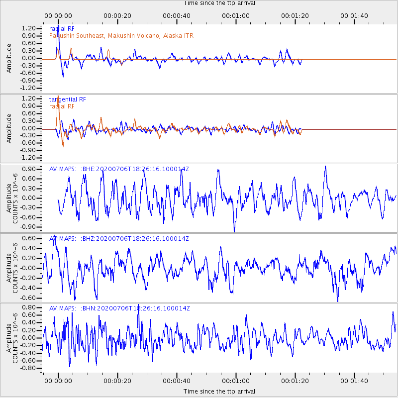
Signal To Noise
| Channel | StoN | STA | LTA |
| AV:MAPS: :BHZ:20200706T18:26:16.100014Z | 1.7283038 | 3.219765E-7 | 1.8629623E-7 |
| AV:MAPS: :BHN:20200706T18:26:16.100014Z | 1.4542493 | 3.4539693E-7 | 2.3750876E-7 |
| AV:MAPS: :BHE:20200706T18:26:16.100014Z | 1.0054473 | 3.9237676E-7 | 3.9025096E-7 |
| Arrivals |
| Ps | 15 SECOND |
| PpPs | 42 SECOND |
| PsPs/PpSs | 56 SECOND |


