You are here: Home > Network List > AV - Alaska Volcano Observatory Stations List
> Station MNAT Nateekin Bay, Makushin Volcano, Alaska > Earthquake Result Viewer
MNAT Nateekin Bay, Makushin Volcano, Alaska - Earthquake Result Viewer
| Earthquake location: |
Southeast Of Honshu, Japan |
| Earthquake latitude/longitude: |
31.5/138.2 |
| Earthquake time(UTC): |
2020/07/06 (188) 18:19:09 GMT |
| Earthquake Depth: |
381 km |
| Earthquake Magnitude: |
5.6 Mww |
| Earthquake Catalog/Contributor: |
NEIC PDE/us |
|
| Network: |
AV Alaska Volcano Observatory |
| Station: |
MNAT Nateekin Bay, Makushin Volcano, Alaska |
| Lat/Lon: |
53.88 N/166.69 W |
| Elevation: |
390 m |
|
| Distance: |
45.0 deg |
| Az: |
43.455 deg |
| Baz: |
263.03 deg |
| Ray Param: |
0.06993964 |
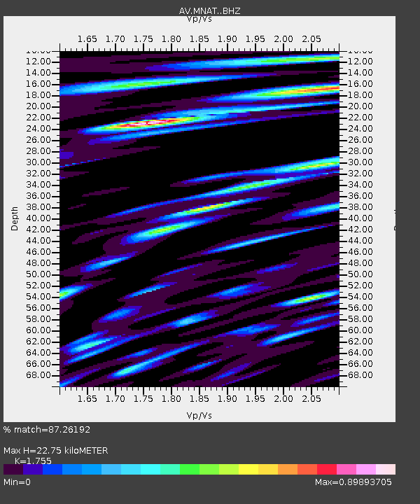
| Estimated Moho Depth: |
22.75 km |
| Estimated Crust Vp/Vs: |
1.75 |
| Assumed Crust Vp: |
3.943 km/s |
| Estimated Crust Vs: |
2.247 km/s |
| Estimated Crust Poisson's Ratio: |
0.26 |
|
| Radial Match: |
87.26192 % |
| Radial Bump: |
400 |
| Transverse Match: |
73.05695 % |
| Transverse Bump: |
400 |
| SOD ConfigId: |
21709731 |
| Insert Time: |
2020-07-20 18:41:51.529 +0000 |
| GWidth: |
2.5 |
| Max Bumps: |
400 |
| Tol: |
0.001 |
|
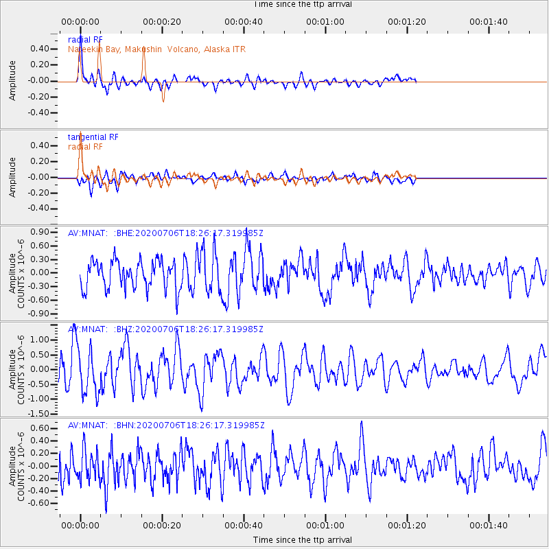
Signal To Noise
| Channel | StoN | STA | LTA |
| AV:MNAT: :BHZ:20200706T18:26:17.319985Z | 1.2426289 | 7.4543567E-7 | 5.99886E-7 |
| AV:MNAT: :BHN:20200706T18:26:17.319985Z | 1.1529465 | 2.3017789E-7 | 1.9964317E-7 |
| AV:MNAT: :BHE:20200706T18:26:17.319985Z | 1.5313542 | 4.637787E-7 | 3.0285528E-7 |
| Arrivals |
| Ps | 4.5 SECOND |
| PpPs | 16 SECOND |
| PsPs/PpSs | 20 SECOND |


