You are here: Home > Network List > AV - Alaska Volcano Observatory Stations List
> Station SPCR Ckakachatna River, Mount Spurr, Alaska > Earthquake Result Viewer
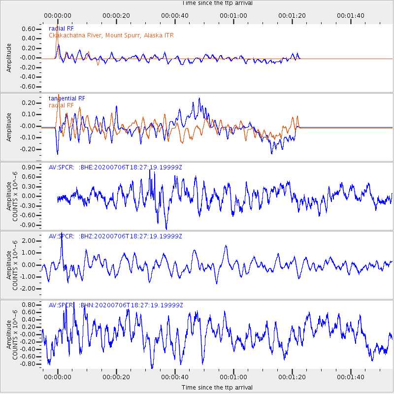
SPCR Ckakachatna River, Mount Spurr, Alaska - Earthquake Result Viewer
*The percent match for this event was below the threshold and hence no stack was calculated.
| Earthquake location: |
Southeast Of Honshu, Japan |
| Earthquake latitude/longitude: |
31.5/138.2 |
| Earthquake time(UTC): |
2020/07/06 (188) 18:19:09 GMT |
| Earthquake Depth: |
381 km |
| Earthquake Magnitude: |
5.6 Mww |
| Earthquake Catalog/Contributor: |
NEIC PDE/us |
|
| Network: |
AV Alaska Volcano Observatory |
| Station: |
SPCR Ckakachatna River, Mount Spurr, Alaska |
| Lat/Lon: |
61.20 N/152.21 W |
| Elevation: |
984 m |
|
| Distance: |
53.2 deg |
| Az: |
34.522 deg |
| Baz: |
269.393 deg |
| Ray Param: |
$rayparam |
*The percent match for this event was below the threshold and hence was not used in the summary stack. |
|
| Radial Match: |
64.84724 % |
| Radial Bump: |
400 |
| Transverse Match: |
74.620415 % |
| Transverse Bump: |
400 |
| SOD ConfigId: |
21709731 |
| Insert Time: |
2020-07-20 18:42:10.280 +0000 |
| GWidth: |
2.5 |
| Max Bumps: |
400 |
| Tol: |
0.001 |
|
Signal To Noise
| Channel | StoN | STA | LTA |
| AV:SPCR: :BHZ:20200706T18:27:19.19999Z | 1.5614848 | 8.0961377E-7 | 5.184897E-7 |
| AV:SPCR: :BHN:20200706T18:27:19.19999Z | 1.3776588 | 2.997149E-7 | 2.175538E-7 |
| AV:SPCR: :BHE:20200706T18:27:19.19999Z | 2.3860595 | 3.7593333E-7 | 1.5755404E-7 |
| Arrivals |
| Ps | |
| PpPs | |
| PsPs/PpSs | |


