You are here: Home > Network List > TA - USArray Transportable Network (new EarthScope stations) Stations List
> Station E20K Nigu River, AK, USA > Earthquake Result Viewer
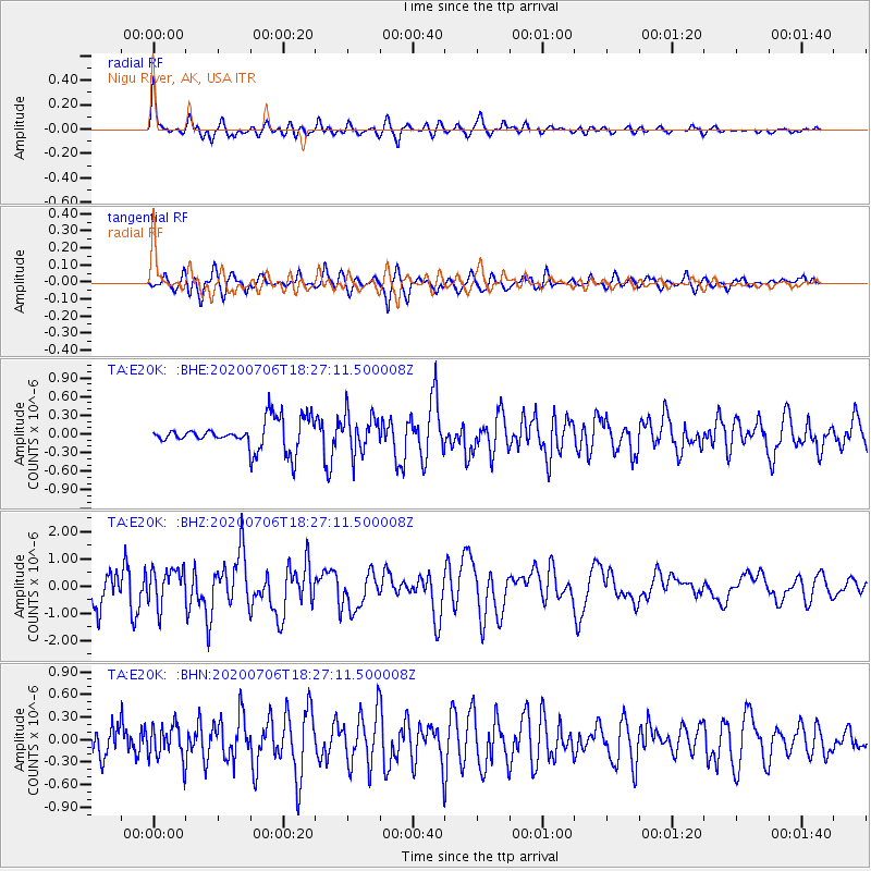
E20K Nigu River, AK, USA - Earthquake Result Viewer
| Earthquake location: |
Southeast Of Honshu, Japan |
| Earthquake latitude/longitude: |
31.5/138.2 |
| Earthquake time(UTC): |
2020/07/06 (188) 18:19:09 GMT |
| Earthquake Depth: |
381 km |
| Earthquake Magnitude: |
5.6 Mww |
| Earthquake Catalog/Contributor: |
NEIC PDE/us |
|
| Network: |
TA USArray Transportable Network (new EarthScope stations) |
| Station: |
E20K Nigu River, AK, USA |
| Lat/Lon: |
68.26 N/156.19 W |
| Elevation: |
866 m |
|
| Distance: |
52.2 deg |
| Az: |
25.457 deg |
| Baz: |
260.291 deg |
| Ray Param: |
0.065430686 |
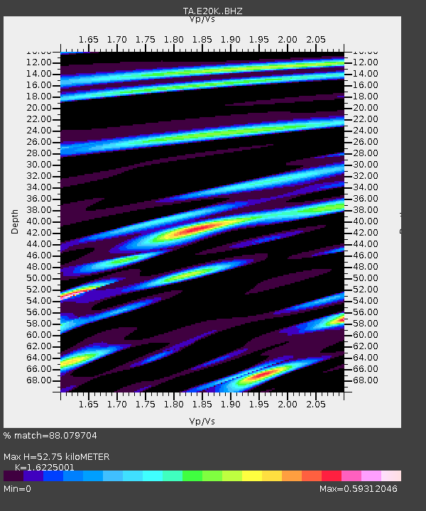
| Estimated Moho Depth: |
52.75 km |
| Estimated Crust Vp/Vs: |
1.62 |
| Assumed Crust Vp: |
6.221 km/s |
| Estimated Crust Vs: |
3.834 km/s |
| Estimated Crust Poisson's Ratio: |
0.19 |
|
| Radial Match: |
88.079704 % |
| Radial Bump: |
400 |
| Transverse Match: |
87.049934 % |
| Transverse Bump: |
400 |
| SOD ConfigId: |
21709731 |
| Insert Time: |
2020-07-20 18:53:39.461 +0000 |
| GWidth: |
2.5 |
| Max Bumps: |
400 |
| Tol: |
0.001 |
|
Signal To Noise
| Channel | StoN | STA | LTA |
| TA:E20K: :BHZ:20200706T18:27:11.500008Z | 1.2058033 | 6.721437E-7 | 5.57424E-7 |
| TA:E20K: :BHN:20200706T18:27:11.500008Z | 1.859191 | 2.295448E-7 | 1.2346489E-7 |
| TA:E20K: :BHE:20200706T18:27:11.500008Z | 1.316131 | 3.045237E-7 | 2.3137795E-7 |
| Arrivals |
| Ps | 5.6 SECOND |
| PpPs | 21 SECOND |
| PsPs/PpSs | 27 SECOND |


