You are here: Home > Network List > TA - USArray Transportable Network (new EarthScope stations) Stations List
> Station F18K Selawik, AK, USA > Earthquake Result Viewer
F18K Selawik, AK, USA - Earthquake Result Viewer
| Earthquake location: |
Southeast Of Honshu, Japan |
| Earthquake latitude/longitude: |
31.5/138.2 |
| Earthquake time(UTC): |
2020/07/06 (188) 18:19:09 GMT |
| Earthquake Depth: |
381 km |
| Earthquake Magnitude: |
5.6 Mww |
| Earthquake Catalog/Contributor: |
NEIC PDE/us |
|
| Network: |
TA USArray Transportable Network (new EarthScope stations) |
| Station: |
F18K Selawik, AK, USA |
| Lat/Lon: |
66.60 N/159.65 W |
| Elevation: |
27 m |
|
| Distance: |
50.5 deg |
| Az: |
27.231 deg |
| Baz: |
258.205 deg |
| Ray Param: |
0.06646141 |
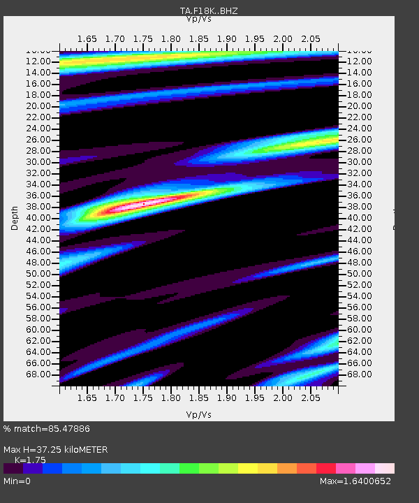
| Estimated Moho Depth: |
37.25 km |
| Estimated Crust Vp/Vs: |
1.75 |
| Assumed Crust Vp: |
6.577 km/s |
| Estimated Crust Vs: |
3.758 km/s |
| Estimated Crust Poisson's Ratio: |
0.26 |
|
| Radial Match: |
85.47886 % |
| Radial Bump: |
400 |
| Transverse Match: |
84.439186 % |
| Transverse Bump: |
400 |
| SOD ConfigId: |
21709731 |
| Insert Time: |
2020-07-20 18:53:55.665 +0000 |
| GWidth: |
2.5 |
| Max Bumps: |
400 |
| Tol: |
0.001 |
|

Signal To Noise
| Channel | StoN | STA | LTA |
| TA:F18K: :BHZ:20200706T18:26:59.625008Z | 1.1852403 | 6.850579E-7 | 5.779907E-7 |
| TA:F18K: :BHN:20200706T18:26:59.625008Z | 2.3126125 | 3.5928912E-7 | 1.5536072E-7 |
| TA:F18K: :BHE:20200706T18:26:59.625008Z | 1.7189728 | 4.470013E-7 | 2.6003977E-7 |
| Arrivals |
| Ps | 4.5 SECOND |
| PpPs | 15 SECOND |
| PsPs/PpSs | 19 SECOND |


