You are here: Home > Network List > TA - USArray Transportable Network (new EarthScope stations) Stations List
> Station F21K Alatna River, AK, USA > Earthquake Result Viewer
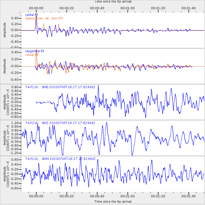
F21K Alatna River, AK, USA - Earthquake Result Viewer

| Earthquake location: |
Southeast Of Honshu, Japan |
| Earthquake latitude/longitude: |
31.5/138.2 |
| Earthquake time(UTC): |
2020/07/06 (188) 18:19:09 GMT |
| Earthquake Depth: |
381 km |
| Earthquake Magnitude: |
5.6 Mww |
| Earthquake Catalog/Contributor: |
NEIC PDE/us |
|
| Network: |
TA USArray Transportable Network (new EarthScope stations) |
| Station: |
F21K Alatna River, AK, USA |
| Lat/Lon: |
67.22 N/153.48 W |
| Elevation: |
597 m |
|
| Distance: |
53.0 deg |
| Az: |
26.934 deg |
| Baz: |
263.69 deg |
| Ray Param: |
0.06486574 |
| Estimated Moho Depth: |
48.75 km |
| Estimated Crust Vp/Vs: |
2.10 |
| Assumed Crust Vp: |
6.455 km/s |
| Estimated Crust Vs: |
3.078 km/s |
| Estimated Crust Poisson's Ratio: |
0.35 |
|
| Radial Match: |
89.210396 % |
| Radial Bump: |
400 |
| Transverse Match: |
70.71647 % |
| Transverse Bump: |
400 |
| SOD ConfigId: |
21709731 |
| Insert Time: |
2020-07-20 18:53:59.058 +0000 |
| GWidth: |
2.5 |
| Max Bumps: |
400 |
| Tol: |
0.001 |
|
Signal To Noise
| Channel | StoN | STA | LTA |
| TA:F21K: :BHZ:20200706T18:27:17.82499Z | 1.1667509 | 5.719911E-7 | 4.902427E-7 |
| TA:F21K: :BHN:20200706T18:27:17.82499Z | 2.2017536 | 1.7833727E-7 | 8.099783E-8 |
| TA:F21K: :BHE:20200706T18:27:17.82499Z | 1.1142776 | 2.0969848E-7 | 1.8819232E-7 |
| Arrivals |
| Ps | 8.7 SECOND |
| PpPs | 22 SECOND |
| PsPs/PpSs | 31 SECOND |


