You are here: Home > Network List > TA - USArray Transportable Network (new EarthScope stations) Stations List
> Station F31M Tsiigehtchic, NWT, CAN > Earthquake Result Viewer
F31M Tsiigehtchic, NWT, CAN - Earthquake Result Viewer
| Earthquake location: |
Southeast Of Honshu, Japan |
| Earthquake latitude/longitude: |
31.5/138.2 |
| Earthquake time(UTC): |
2020/07/06 (188) 18:19:09 GMT |
| Earthquake Depth: |
381 km |
| Earthquake Magnitude: |
5.6 Mww |
| Earthquake Catalog/Contributor: |
NEIC PDE/us |
|
| Network: |
TA USArray Transportable Network (new EarthScope stations) |
| Station: |
F31M Tsiigehtchic, NWT, CAN |
| Lat/Lon: |
67.44 N/133.74 W |
| Elevation: |
56 m |
|
| Distance: |
60.6 deg |
| Az: |
26.26 deg |
| Baz: |
281.545 deg |
| Ray Param: |
0.060059026 |
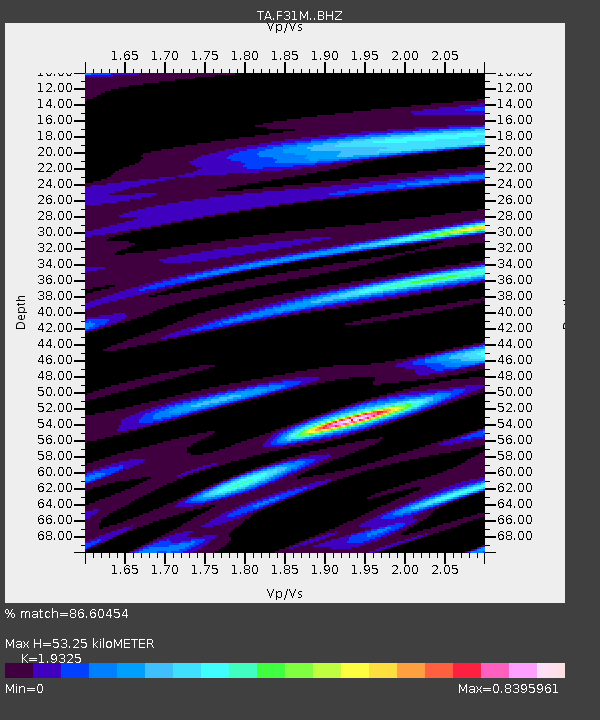
| Estimated Moho Depth: |
53.25 km |
| Estimated Crust Vp/Vs: |
1.93 |
| Assumed Crust Vp: |
6.171 km/s |
| Estimated Crust Vs: |
3.193 km/s |
| Estimated Crust Poisson's Ratio: |
0.32 |
|
| Radial Match: |
86.60454 % |
| Radial Bump: |
400 |
| Transverse Match: |
80.53074 % |
| Transverse Bump: |
400 |
| SOD ConfigId: |
21709731 |
| Insert Time: |
2020-07-20 18:54:09.181 +0000 |
| GWidth: |
2.5 |
| Max Bumps: |
400 |
| Tol: |
0.001 |
|
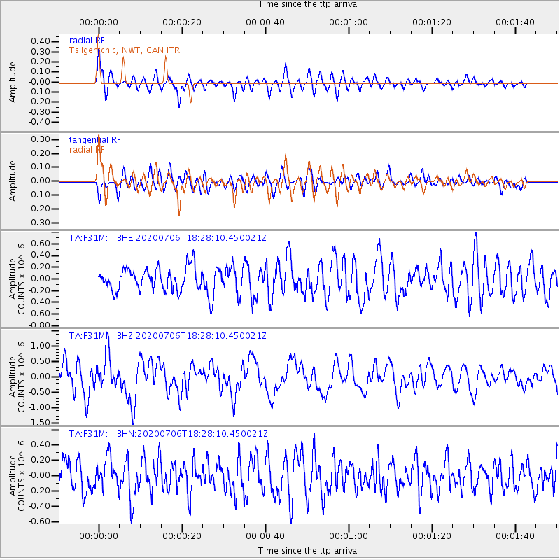
Signal To Noise
| Channel | StoN | STA | LTA |
| TA:F31M: :BHZ:20200706T18:28:10.450021Z | 1.200765 | 5.7159855E-7 | 4.7602865E-7 |
| TA:F31M: :BHN:20200706T18:28:10.450021Z | 1.3873063 | 1.8950455E-7 | 1.3659891E-7 |
| TA:F31M: :BHE:20200706T18:28:10.450021Z | 1.1740602 | 2.1430974E-7 | 1.8253725E-7 |
| Arrivals |
| Ps | 8.4 SECOND |
| PpPs | 24 SECOND |
| PsPs/PpSs | 33 SECOND |


