You are here: Home > Network List > TA - USArray Transportable Network (new EarthScope stations) Stations List
> Station G31M Satah River, YT, CAN > Earthquake Result Viewer
G31M Satah River, YT, CAN - Earthquake Result Viewer
| Earthquake location: |
Southeast Of Honshu, Japan |
| Earthquake latitude/longitude: |
31.5/138.2 |
| Earthquake time(UTC): |
2020/07/06 (188) 18:19:09 GMT |
| Earthquake Depth: |
381 km |
| Earthquake Magnitude: |
5.6 Mww |
| Earthquake Catalog/Contributor: |
NEIC PDE/us |
|
| Network: |
TA USArray Transportable Network (new EarthScope stations) |
| Station: |
G31M Satah River, YT, CAN |
| Lat/Lon: |
66.92 N/134.27 W |
| Elevation: |
61 m |
|
| Distance: |
60.5 deg |
| Az: |
26.893 deg |
| Baz: |
281.369 deg |
| Ray Param: |
0.06012244 |
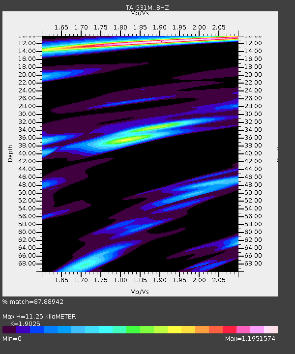
| Estimated Moho Depth: |
11.25 km |
| Estimated Crust Vp/Vs: |
1.90 |
| Assumed Crust Vp: |
6.171 km/s |
| Estimated Crust Vs: |
3.244 km/s |
| Estimated Crust Poisson's Ratio: |
0.31 |
|
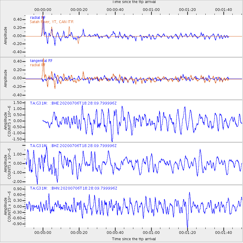
| Radial Match: |
87.88942 % |
| Radial Bump: |
400 |
| Transverse Match: |
70.025826 % |
| Transverse Bump: |
400 |
| SOD ConfigId: |
21709731 |
| Insert Time: |
2020-07-20 18:54:26.772 +0000 |
| GWidth: |
2.5 |
| Max Bumps: |
400 |
| Tol: |
0.001 |
|
Signal To Noise
| Channel | StoN | STA | LTA |
| TA:G31M: :BHZ:20200706T18:28:09.799996Z | 1.1431427 | 8.1437145E-7 | 7.12397E-7 |
| TA:G31M: :BHN:20200706T18:28:09.799996Z | 1.6890093 | 2.2925263E-7 | 1.3573201E-7 |
| TA:G31M: :BHE:20200706T18:28:09.799996Z | 1.4771551 | 5.6759217E-7 | 3.8424685E-7 |
| Arrivals |
| Ps | 1.7 SECOND |
| PpPs | 5.1 SECOND |
| PsPs/PpSs | 6.8 SECOND |


