You are here: Home > Network List > TA - USArray Transportable Network (new EarthScope stations) Stations List
> Station I20K Naaghedeneel ne tl'uh kk'aat, AK, USA > Earthquake Result Viewer
I20K Naaghedeneel ne tl'uh kk'aat, AK, USA - Earthquake Result Viewer
| Earthquake location: |
Southeast Of Honshu, Japan |
| Earthquake latitude/longitude: |
31.5/138.2 |
| Earthquake time(UTC): |
2020/07/06 (188) 18:19:09 GMT |
| Earthquake Depth: |
381 km |
| Earthquake Magnitude: |
5.6 Mww |
| Earthquake Catalog/Contributor: |
NEIC PDE/us |
|
| Network: |
TA USArray Transportable Network (new EarthScope stations) |
| Station: |
I20K Naaghedeneel ne tl'uh kk'aat, AK, USA |
| Lat/Lon: |
64.80 N/154.48 W |
| Elevation: |
75 m |
|
| Distance: |
52.4 deg |
| Az: |
29.929 deg |
| Baz: |
264.596 deg |
| Ray Param: |
0.06528798 |
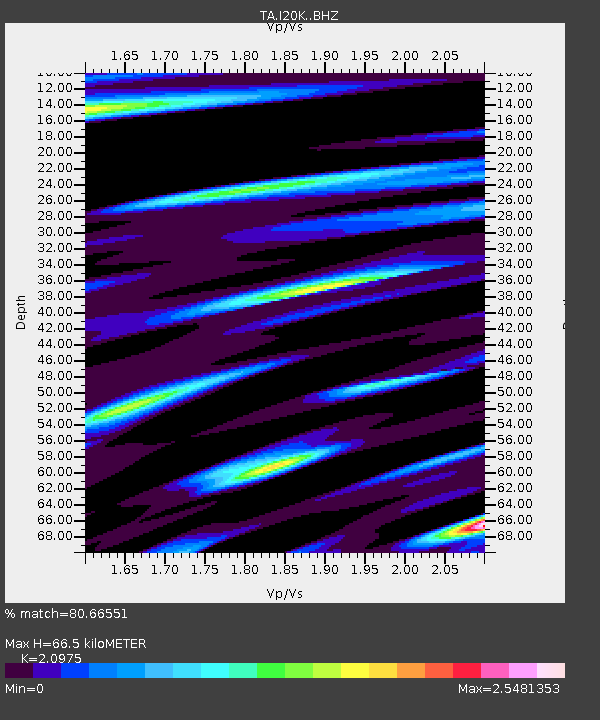
| Estimated Moho Depth: |
66.5 km |
| Estimated Crust Vp/Vs: |
2.10 |
| Assumed Crust Vp: |
6.566 km/s |
| Estimated Crust Vs: |
3.13 km/s |
| Estimated Crust Poisson's Ratio: |
0.35 |
|
| Radial Match: |
80.66551 % |
| Radial Bump: |
400 |
| Transverse Match: |
64.44244 % |
| Transverse Bump: |
400 |
| SOD ConfigId: |
21709731 |
| Insert Time: |
2020-07-20 18:54:40.889 +0000 |
| GWidth: |
2.5 |
| Max Bumps: |
400 |
| Tol: |
0.001 |
|

Signal To Noise
| Channel | StoN | STA | LTA |
| TA:I20K: :BHZ:20200706T18:27:13.100014Z | 1.6847914 | 1.1009117E-6 | 6.5344096E-7 |
| TA:I20K: :BHN:20200706T18:27:13.100014Z | 1.4937491 | 5.351921E-7 | 3.5828782E-7 |
| TA:I20K: :BHE:20200706T18:27:13.100014Z | 1.2382567 | 6.4158377E-7 | 5.181347E-7 |
| Arrivals |
| Ps | 12 SECOND |
| PpPs | 30 SECOND |
| PsPs/PpSs | 42 SECOND |


