You are here: Home > Network List > TA - USArray Transportable Network (new EarthScope stations) Stations List
> Station L29M Grand Valley Creek, YT, CAN > Earthquake Result Viewer
L29M Grand Valley Creek, YT, CAN - Earthquake Result Viewer
| Earthquake location: |
Southeast Of Honshu, Japan |
| Earthquake latitude/longitude: |
31.5/138.2 |
| Earthquake time(UTC): |
2020/07/06 (188) 18:19:09 GMT |
| Earthquake Depth: |
381 km |
| Earthquake Magnitude: |
5.6 Mww |
| Earthquake Catalog/Contributor: |
NEIC PDE/us |
|
| Network: |
TA USArray Transportable Network (new EarthScope stations) |
| Station: |
L29M Grand Valley Creek, YT, CAN |
| Lat/Lon: |
63.11 N/138.13 W |
| Elevation: |
918 m |
|
| Distance: |
59.6 deg |
| Az: |
31.585 deg |
| Baz: |
280.214 deg |
| Ray Param: |
0.060691744 |
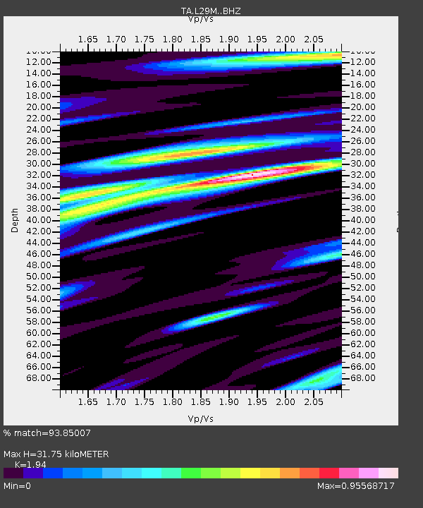
| Estimated Moho Depth: |
31.75 km |
| Estimated Crust Vp/Vs: |
1.94 |
| Assumed Crust Vp: |
6.566 km/s |
| Estimated Crust Vs: |
3.385 km/s |
| Estimated Crust Poisson's Ratio: |
0.32 |
|
| Radial Match: |
93.85007 % |
| Radial Bump: |
400 |
| Transverse Match: |
85.882965 % |
| Transverse Bump: |
400 |
| SOD ConfigId: |
21709731 |
| Insert Time: |
2020-07-20 18:54:59.933 +0000 |
| GWidth: |
2.5 |
| Max Bumps: |
400 |
| Tol: |
0.001 |
|
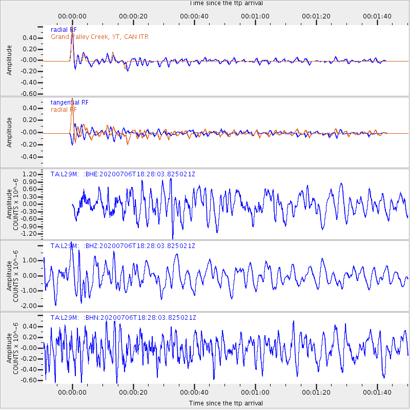
Signal To Noise
| Channel | StoN | STA | LTA |
| TA:L29M: :BHZ:20200706T18:28:03.825021Z | 1.5567029 | 1.1584243E-6 | 7.441525E-7 |
| TA:L29M: :BHN:20200706T18:28:03.825021Z | 1.3171189 | 2.5882485E-7 | 1.9650835E-7 |
| TA:L29M: :BHE:20200706T18:28:03.825021Z | 1.5693971 | 5.98692E-7 | 3.8147897E-7 |
| Arrivals |
| Ps | 4.7 SECOND |
| PpPs | 14 SECOND |
| PsPs/PpSs | 18 SECOND |


