You are here: Home > Network List > TD - TransAlta Monitoring Network Stations List
> Station TD023 Z > Earthquake Result Viewer
TD023 Z - Earthquake Result Viewer
| Earthquake location: |
Southeast Of Honshu, Japan |
| Earthquake latitude/longitude: |
31.5/138.2 |
| Earthquake time(UTC): |
2020/07/06 (188) 18:19:09 GMT |
| Earthquake Depth: |
381 km |
| Earthquake Magnitude: |
5.6 Mww |
| Earthquake Catalog/Contributor: |
NEIC PDE/us |
|
| Network: |
TD TransAlta Monitoring Network |
| Station: |
TD023 Z |
| Lat/Lon: |
51.11 N/114.31 W |
| Elevation: |
1169 m |
|
| Distance: |
76.1 deg |
| Az: |
38.266 deg |
| Baz: |
302.922 deg |
| Ray Param: |
0.05016958 |
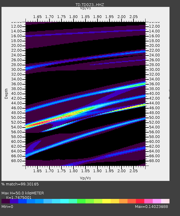
| Estimated Moho Depth: |
50.0 km |
| Estimated Crust Vp/Vs: |
1.75 |
| Assumed Crust Vp: |
6.178 km/s |
| Estimated Crust Vs: |
3.535 km/s |
| Estimated Crust Poisson's Ratio: |
0.26 |
|
| Radial Match: |
99.30165 % |
| Radial Bump: |
52 |
| Transverse Match: |
98.7732 % |
| Transverse Bump: |
76 |
| SOD ConfigId: |
21709731 |
| Insert Time: |
2020-07-20 18:55:46.585 +0000 |
| GWidth: |
2.5 |
| Max Bumps: |
400 |
| Tol: |
0.001 |
|

Signal To Noise
| Channel | StoN | STA | LTA |
| TD:TD023: :HHZ:20200706T18:29:44.620003Z | 1.3836938 | 4.9972264E-6 | 3.6115116E-6 |
| TD:TD023: :HH1:20200706T18:29:44.620003Z | 1.1559044 | 6.0660284E-7 | 5.2478634E-7 |
| TD:TD023: :HH2:20200706T18:29:44.620003Z | 1.3813024 | 7.0383385E-6 | 5.0954363E-6 |
| Arrivals |
| Ps | 6.2 SECOND |
| PpPs | 22 SECOND |
| PsPs/PpSs | 28 SECOND |


